
6/17 – Day 59
11.6 (+3.5) miles from Mammoth Pass to Agnew Meadows
In the morning at our AirBnB in Mammoth Lakes, CA, I made steak and eggs for the group. We finished the final act of Chitty Chitty Bang Bang and now I never need to watch it again. Then, we checked out and grabbed a drink at Mammoth Coffee Roasters.


This was Carebear’s last day before leaping ahead on trail (he was just section hiking), so it meant we were saying goodbye. Even though it had only been a week since we met him, going through the Sierra together was a bonding experience like no other.

Noon rolled around and we took the town trolley to the Village of Mammoth Lakes. I had a beer at Mammoth Brewing before the hourly trolley to the mountains came along. We boarded with dozens of bikers and made it back to Horseshoe Lake by 1:30pm. From here, we still needed to hike 3.5 miles to reach the PCT, yet another detour that made it feel like our progress has been lumbering since entering the Sierra. The good news is that we really enjoyed Mammoth Lakes and the hike back over Mammoth Pass was not difficult at all.

Once back on the PCT at Deer Creek, Spout and I continued hiking north. Notably, we passed a mountain called Red Cone and walked through a brief burn section before reaching Red’s Meadow. It was unusually hot for the mountains and yet another cloudless day.

The highlight of the hike was Devil’s Postpile, a National Monument protecting a unique, hexagonal basalt formation. I learned that the columns were formed by lava cooling in a process called “jointing”.

The remainder of the hike was through a rich evergreen forest. The bridge over the North fork of San Jauquin River was destroyed, so we were forced to cross on a fallen log upstream. Spout faced her crippling fear of falling once again and lived to tell the tale. A few miles later, we made camp at Agnew Meadows. This campsite was a bloodletting clinic in disguise. We dove in our tents as fast as possible to hide from a vicious mosquito horde.


6/18 – Day 60
16.9 miles from Agnew Meadows to Lyell Creek
Hiking out of Agnew Meadows took us along a scenic ridge for several miles. We hiked with Hottub, climbing towards Donahue Pass throughout the morning. We came upon Thousand Island Lake, along with at least ten other hikers who were all but forced to stop and admire the landscape.

Thousand Island Lake – 10/10
Swim? Yes

Though not marked with a duck for some reason, this lake was by far the best swimming experience of the Sierra. The water was tolerable, the floor was soft and muddy, and the mountains beyond were truly incredible.

Unfortunately, Spout took a bad fall shortly after our lunch break at the lake. She bruised both of her knees and cut up her hand. The swelling made movement slow and painful. What did not help was that we were nearly halfway up Donahue Pass. The trail was fairly steep, rocky, and flooded at some points.

A series of difficult miles followed, but we eventually made it to the summit around 5:00pm. Donahue Pass was significant because it marked the entrance to Yosemite National Park and was the last time we would be above 11,000′ on the PCT. We soaked in an epic view of the park, then began the descent.

Heading down was quite easy, as far as terrain is concerned. Virtually all of the snow had melted. However, Spout’s knee was throbbing in pain and we never quite fell into a groove. We stopped short of our goal at a site away from Lyell Creek for the night. We both hoped that some rest would do her injury some good.
6/19 – Day 61
10.8 miles from Lyell Creek to Tuolumne Meadows (Lake May Campground)
I hate writing about the lows on trail. Not doing so, however, creates an unrealistic depiction of backpacking. Negative attitudes are amplified by the discomfort of hiking and Spout and I were not happy campers during our morning stroll through Lyell Canyon.


I hiked miserably through the ancient remains of a post-glaciated meadow. Unimpressive. The trail was perfectly flat, obstacle free, and featured mile after mile of pristine wilderness. The only thing on my mind though, was reaching the road at Tuolumne Meadows. Spout’s injury was bad enough that we were debating getting off trail for a day, but figured we should see if a hot meal and cold drink would be a quick remedy.

At the Tuolumne Meadows Store, we ran into a few familiar hikers, including our friend, Chef. We hiked with him last year during our loop of the Tahoe Rim Trail and just so happened to run into him again as he was finishing a backpacking trip out of Yosemite Valley. His fiancee, Spider Face, was finishing up her first ever backpacking trip.

We felt like we were falling behind schedule after the last couple of weeks, but Spout said she felt she could hike through her injury. Neither of us had been to Yosemite before and we decided it was too good of an opportunity to pass up a trip into the Yosemite Valley, our final side quest of the Sierra. The permit situation for anything off of the PCT is nightmarish, but we tried our luck politely asking a ranger about our options just before they closed. We scored some permits for camping at Lake May, which enabled us to hike into the valley the following morning.

From Tuolumne Meadows, we hitched with some enthusiastic travellers to the Lake May Trailhead. They even asked for a group selfie after dropping us off. Some campers at Lake May also recognized us as PCT hikers and gave us kudos. The admiration was uplifting, especially on a day we both felt discouraged.

6/20 – Day 62
5.8 (+20) miles from Tuolumne Meadows to Glen Aulin Sierra Camp
We beat the sunrise waking up and filled up our bottles from Lake May as light was first coming over the horizon. To reach Sunrise Trailhead, we re-hiked 3 miles downhill to the road towards Tenaya Lake. From here, we began trekking towards Yosemite Valley. We forded a small stream to the amazement of a trio of puzzled day hikers.

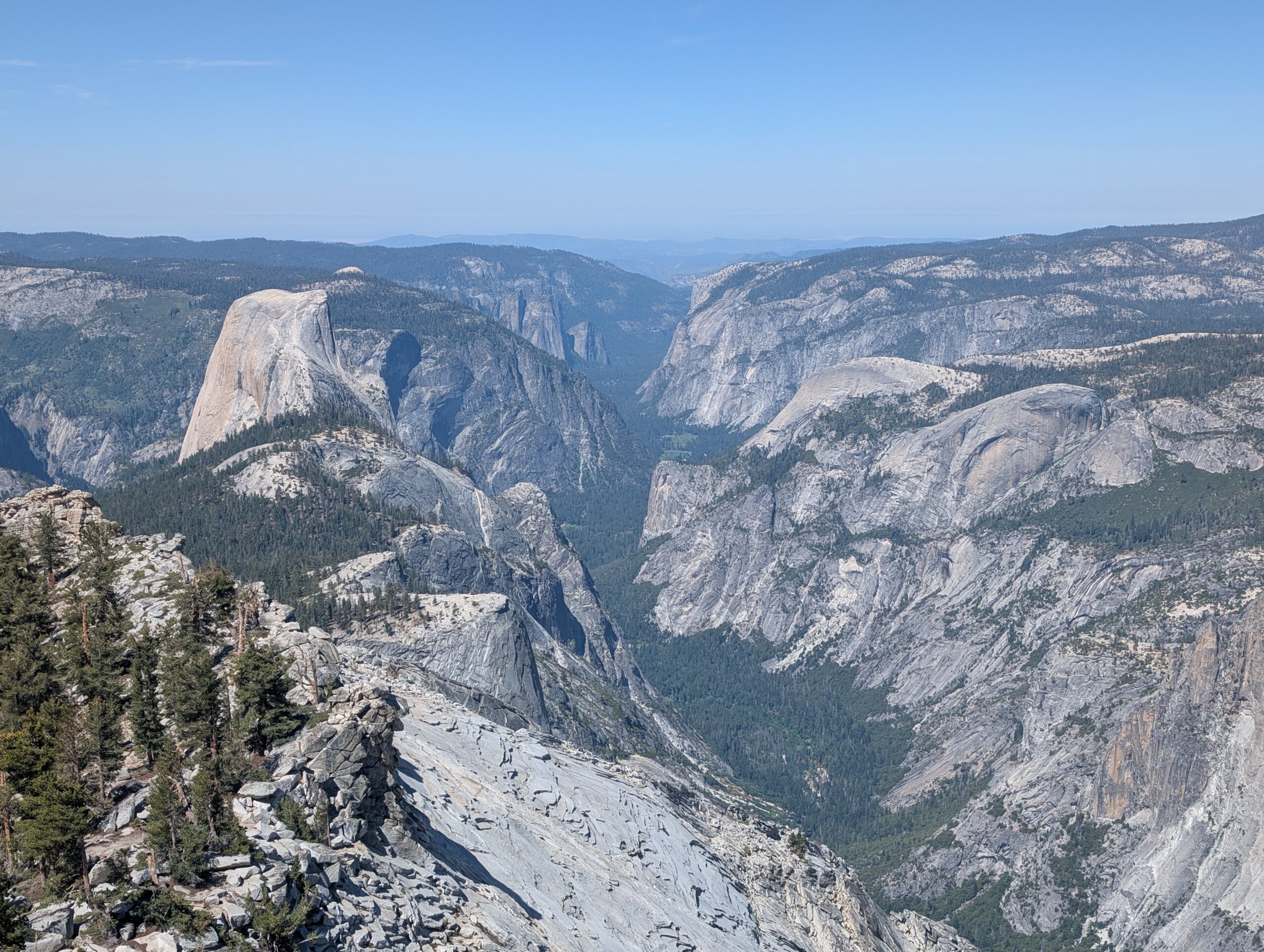
The climb to Cloud’s Rest involved two, manageable humps, a thousand feet up each. Since we were not starting in the valley, there was not nearly as much ascent. The trail was wooded and we did not receive many views until the final mile of the climb. The drawn out introduction to Yosemite Valley was well worth the wait. We hopped along the rocky ridge to the summit of Cloud’s Rest at 9,930′ and were treated to a spectacular view of one of the most iconic landscapes in the world.

We ran into Swanson at the top, a long lost desert friend. We ate lunch and took plenty of photos while fending off chipmunks. The perk of being carless drifters was that we did not need to hike out-and-back, and could continue heading west into the valley. The view of Half Dome from southwest corner of Cloud’s Rest was truly awe-inspiring.

Along the way, we witnessed a momma Grouse cooing her two baby chicks to follow. Several miles down the mountain was the top of Nevada Fall, spilling hundreds of feet into a canyon below. While we had been passing day hikers here and there throughout the day, as soon as we started following the Mist Trail, it turned into a circus.

It was jarring to go from complete isolation throughout the Sierra, to a heavily trafficked park so suddenly. The descent into the valley had nearly as many people as rocks, and the the trail itself turned into a rock staircase for several miles. It was unexpectedly difficult and much steeper than the PCT at any point. All of this said, it was still wonderful and scenic. Vernal Fall was the second majestic waterfall we passed on the Mist Trail, just before reaching the valley.

Yosemite Valley is effectively a town, divided into several regions with multiple roads serviced by a bus line. From Happy Isle where we popped out, we waited for two busses (the first was packed full) and rode it to the bustling Curry Village. Here, we ordered pizza from The Deck and sat eating for a few hours until 5:00pm or so.

We did not have a permit to camp anywhere tonight, which meant we needed a ride back to Tuolumne Meadows to rejoin the PCT. However, it was an hour and a half drive away. We pulled off a three part hitch: one to the base of El Capitan on the outbound road, one to a random turnoff by the park exit, and one all the way back to Tuolumne Meadows.

The longest leg of the journey was courtesy of a woman who was starting a job the next day at the Tuolumne Meadows Grill, which was exactly where we were also headed. About an hour into the drive, her tire popped and we assisted in replacing the spare. It was past 7:30pm when we made it back to the PCT. The real kicker was that the next six miles were a “No Camping” zone, so we had some more hiking to do.

The evening walk was nearly all perfectly flat trail through the meadow. We passed Soda Springs, a mysterious spring that bubbles up from the Earth naturally carbonated. Its metallic taste made it seem like a throwaway flavor of La Croix.

As night settled, the trail grew progressively rockier. We crossed a few bridges and traversed smooth, granite surfaces, poking in and out of spooky evergreen forest. We eventually reached Glen Aulin Sierra Camp by the light of our headlamps. It was a much longer day of hiking than I had originally planned my legs felt sore for the first time in weeks.

6/21 – Day 63
19.0 miles from Glen Aulin Sierra Camp to Dispersed Campsite
We slept in past 7:00am, then packed up and explored the campground. There was a large waterfall that we had missed by the entrance. For several miles north, we followed exceptionally pleasant terrain through more meadows with rounded mountains in the distance.


I packed out three slices of pizza and two pieces of cheesy garlic bread wrapped in paper plates. Enjoying cold pizza in the Yosemite backcountry was a bucket list item I did not even know I had. Further up the trail, we reached Miller Lake for second lunch.

Miller Lake – 6.5/10
Swim? Yes

The champagne of lakes, they say. This one had a nice setting, but it was too cold and the wind was blowing hard. The swim was not very enjoyable and Spout refused to jump in.

The passes have been shrinking as we progress north out of the Sierra. However, Benson Pass still stood in our way at 10,107′. The uphills in the park have been quite steep by PCT standards and are often crafted on cobblestone-like path. The views in this section were dramatic, and I quickly learned to appreciate the signature look of round, granite peaks decorated with pine. Spout called it, “Domecemite”.

After tackling the pass, we walked down to find a small campsite on a ledge. We could not stake the tent properly, so we used heavy rocks to pin down the corners. This was the first time we have tented on solid rock. It was slanted and small stones were piercing Spout through her pad, but at least the view was pretty.


6/22 – Day 64
15.9 miles from Dispersed Campsite to Macomb Ridge
The morning brought a few surprises with it. Everything had frosted outside our tent (this was the first night of Summer, by the way). Also, Spout’s side of the sleeping pad was suspiciously low on air. Turns out the abrasion from rocks underneath the pad punctured it as we slid around at night. Fortunately, there was a lake only a mile down the trail so I could quickly patch the leak.

Smedberg Lake – 7/10
Swim? Yes

This was strictly a utility lake for me to dunk the inflated sleeping pad underwater to find where the bubbles were escaping. Since I was already halfway in the water I figured I might as well swim.

The terrain today was about the most rugged the PCT has been. The grade of the hills was steeper and they hit one after another. There were multiple small lakes and the landscape was lush. Spout described Kings Canyon as majestic, while Yosemite feels whimsical.

Maybe the twenty mile side trail into the valley was more grueling than anticipated, but this section absolutely cooked us. The climb up Seavey Pass and unnamed gaps in the canyon walls were exhausting and left us heaving for air.

We made camp in the middle of one of these hills. There have been abundant black-tailed deer throughout Yosemite. A doe walked within a few feet of us as we were making dinner and proceeded to run amuk around our tent all night long. We later learned that deer love to lick the salt from urine, which is probably why it hung around. It is gross and I wish they would not.
6/23 – Day 65
23.6 miles from Macomb Ridge to Leavitt Lake Junction
Dark clouds were blocking the sun when we rose from our tent. It appeared rain was imminent. The same doe was still lurking around our tent as we packed up. We said farewell to our furry friend and continued hiking to Canada.


Wilma Lake – 3.5/10
Swim? Yes

What this lake lacks in beauty, it makes up for in mosquitos. The floor was muddy and the shore was flooded to the grass. The signs all referred to this as Wilmer Lake, even though Wilma Lake is the official name. There is not much else to say about a lake that cannot even get its name right.

The next ten, uphill miles to Dorothy Lake Pass were back to familiar grade. In general, the PCT rarely ascends/descends steeper than 500ft/mi, with Yosemite being the only exception during the last couple of days. For comparison, that would be a very average grade on the AT (not even considering the rocks).

The trail followed faithfully along Falls Creek, passing through Grace Meadow. The mosquitos during this stretch were absolutely horrific. Taking a five minute break to filter water was becoming inexcusable. If we stopped moving, we were swarmed. In a way, this played to our advantage as we set a strong pace throughout the afternoon. When my stomach inevitably began to rumble, we had no other choice but to pitch the tent for some refuge. No exaggeration, there were at least a hundred mosquitos perched on the mesh of our tent trying to kill us as we ate. After frantically tearing down the tent, we continued the remainder of the climb to the pass.
Dorothy Lake – 8/10
Swim? Yes

As thunder rumbled in the distance and raindrops began to fall, I idiotically jumped in the final lake of the high Sierra. The setting was beautiful and had it not been cold and windy, this would have been a prime swimming lake.

Dorothy Lake Pass was perhaps the easiest pass of the Sierra, a sign of the weakening terrain that lay ahead. As we crested the summit, snow flurries began to white out the surroundings. This was the northern border of Yosemite National Park and seeing the mountains disappear in the wintery mix was poetic.

The storm never quite developed into anything serious. We continued hiking through the chill for several more miles and eventually reached a sign that said, “1000”. The bridge over Walker River was mangled from a heavy snowfall years ago, but still structurally sound enough for us to cross. We entered a new cluster of mountains where granite was absent. Leavitt Peak was composed of a brownish orange, volcanic rock.


6/24 – Day 66
10.1 miles from Leavitt Lake Junction to Sonora Pass (Kennedy Meadows North)
The morning was absolutely beautiful from our site on the ridge. The new clothes fit the mountains well. Some trends die hard though, like the stubborn snow patches that plagued the upper elevations. We made the climb along scenic switchbacks to break 10,000′.

This stretch of trail felt particularly dramatic and, in many ways, bittersweet. The end of the high Sierra was only a few miles ahead. I knew I would miss the epic backdrops and consistent alpine lakes. Spout, however, was ready for it to be over. The ridge walk provided quite a few sketchy scrambles over rocks and traverses through the snow, none of which excited her.

After a half dozen miles along the ridge crest, the trail began a steep descent towards Sonora Pass. The snow reluctantly let up as we neared the bottom and we cruised to the road by noon. We stopped the first car that drove past, a man who was proud to be doing his part in revitalizing the hitch-hiking culture of the 60s. He was kind enough to take us eight miles down the road to Kennedy Meadows North.

Kennedy Meadows North has literally no relation to Kennedy Meadows South and I hate that it is named this way. The coincidence is that either location is a symbolic terminus of the section that most people consider the Sierras.

Spout and I explored the ranch, which was primarily a cowboy training facility (no kidding). There was a store with an impressive resupply selection and an attached restaurant that served home-grown beef burgers and steaks. We payed a couple bucks to do laundry and I took my third shower in the month of June. Hiking out was not as appealing as hot food, so we decided to pitch our tents and spend the night.

What’s Next?
We have made it to the spiritual end of the Sierra. Northbound, however, there are still a few hundred miles of the mountain range. Lake Tahoe and the Desolation Wilderness are upcoming as we enter Northern California.
How’s It Going?
It was fortunate that Spout’s fall only resulted in bruises, rather than something internal. Still, I am sure it was not easy for her to hike on the injury. I am continuously impressed by her resilience and toughness!
Her injury also contributed to struggles we both shared on the mental side. It is so easy to become discouraged. Progress is painfully slow and there are too many opportunities to question why we are out here. One day I feel like I am on top of the world, the next I am day dreaming about being literally anywhere else. Such is life.
Food & Resupply
Our new favorite dinner is an original meal, inspired by chicken and waffles. Stove Top stuffing, a chicken packet, and white gravy mix create a delicious and hearty meal. The gravy is the star here, but the chicken adds some protein and the stuffing is important for texture.
I should mention how amazing Peanut Butter M&M’s are for backpacking. They are one of the most calorie dense snacks you can buy and even higher calorie per gram than Peanut M&M’s.
Bobo’s makes consistently delicious oat bars that have been my go to breakfasts for a while. I found the new, Bobo’s Protein Bars at Grocery Outlet and they are quite possibly the worst bars I have ever tasted. The texture is grainy from the pea protein, so every bite is a chore. Do not buy.
Notes
- The duck challenge ends for me at Sonora Pass. In total, I counted 18 alpine lakes marked with a duck icon on FarOut
- I missed Chicken Sprints Lake, Arrowhead Lake, and a random, unnamed “small lake”. Additional lakes I swam in include Wanda Lake, Sapphire Lake, and Thousand Island Lake
Sooooo much fun reading all this!! I am continually amazed at your progress and …….by all means. Your courage!!
Hugs, Gram Carol
7-2-25 Happy Birthday Yeti💞#29👍💖!
Keep on a’goin! Hugs.
Love you.
Gram Carol
Thank you! ❤️