
9/9 – Day 143
11.2 miles from High Bridge to Six Mile Campground
It was a slow and beautiful morning in Stehekin, WA. Bottomless coffee from the lodge held us over until the 12:30pm shuttle arrived and us over to the bakery. A woman on the bus said she knew that we were thru-hikers because she “saw the movie”, then asked us a million questions, like whether or not we we knew that we smelled bad. I had no idea, lady. Sometimes I get a whiff of my putrid shorts that have soaked up fifteen liters of sweat and farts in the past week, and I cannot differentiate them from a bundle of roses.


Happy to escape the interrogation, we vortexed at the bakery again. I literally tried over half of their offerings between both days. A few of us walked down the road to The Garden, a property owned by a profoundly chill, barefoot man named Carl. He sold a healthy variety of fresh produce, including some juicy red pears that I can only describe as life-changing.

Back at the pastry shop, we ate until we felt sick, solved crosswords, and napped in the grass before the 2:00pm shuttle rolled by to take us back to the trail.

A light rain had passed before we started to hike. The trail rose gradually alongside the Stehekin River. A dramatic canyon with wispy clouds was the backdrop for the last few miles.

Still within the boundaries of the National Park, we had to camp at specific, established sites. Six Mile Campsite had more than enough space to accommodate all of us.

9/10 – Day 144
29.0 miles from Six Mile Campground to Glacier Pass
The weather was beginning to reach optimal September conditions. It was bright and sunny all day, with only a few clouds, and a high in the low 80s. From the campground, we continued up an impressively well-graded climb. It was technically over 20 miles long, but hardly felt like we were heading uphill.

The final major, paved road of the PCT was Rainy Pass. Just six miles from the trailhead, we crested Cutthroat Pass and were transported into another world. If this was the only view we saw after hiking 2,600 miles, it may have been still been worth it.

A huge group of hikers gathered to enjoy a spectacular viewpoint for lunch, including the usual suspects, plus Deep End, Porky, Fishstick, Greenlight, Happy Meal, and Footlocker. At length, everyone dispersed and followed the trail around the exposed canyon rim above the Methow River.

We stopped to filter water with 100 Grand, Stag, and AC, then questioned how many more times we would need to do everyone’s least favorite chore again. We were in countdown mode: 50 more miles, 3 more days.

Spout and I pushed a bit later into the night than usual, rolling into a campsite at Glacier Pass after 9:00pm. The rest of the hikers we knew either stopped earlier, or continued overnight in a bid to reach the terminus tomorrow.
9/11 – Day 145
34.1 miles from Glacier Pass to Hopkins Lake
The meaning of a pass continued to baffle me. Glacier Pass seemed to a random, flat clearing halfway up a huge hill to Grasshopper Pass. We knocked out the rest of the climb first thing in the morning, then hiked along a wooded ridge for ten more miles.


At last, we reached Harts Pass, the northernmost road on the PCT. This would be the location we would be hitching out from after completing the trail. It was surreal to reach this point of the hike. Doc was waiting for us here, and we hiked out with him, Snapshot, and Greenlight for a short while.

This portion of the trail was really special, because heading in the opposite direction were hikers we knew, who had just completed their journeys and were headed home. Every time someone passed, we would congratulate one another and fist bump. We made it.

Of all those we passed, Janick and Woody were the most impactful. Friendships that began thousands of miles ago were bubbling under a pressure cooker. Everyone knew what everyone else had gone through, because they went through the same ordeal.

The final 30 miles really emphasized the “crest” part of PCT. The trail navigated several epic mountains, over Rock Pass and Woody Pass. Inching ever closer to the Canadian wilderness, the views were outstanding. I expected nothing less at this point.

Nightfall came and left us blazing the path by light of headlamps one final time. We felt good, like really good, and even contemplated hiking all the way to the northern terminus tonight.

As we carefully stepped between rocks in the dark, a single headlamp approached from the north. Snake Eyes, finishing up a monster, 70 mile push to achieve his triple crown, was heading back already.

Spout and I loved hiking at night. The atmosphere was calm, yet eerie, and we had the trail to ourselves. We soaked in the darkness for as long as our bodies could tolerate, though our endurance was now solely limited to the necessity of sleep. After 34 miles and over 7’000′ of elevation gain, I still had gas in the tank, but we decided it would be best to enjoy the moment in the morning. We pulled off at Hopkins Lake and made camp at 10:30pm.


9/12 – Day 146
6.4 (+17.1) miles from Hopkins Lake to Canada
Though my alarm was set for 7:00am, I was up a half hour earlier. Spout was stirring before much longer. Maybe I woke her up, I do not know. Feeling refreshed, we started our short, downhill hike to the border through the misty woods.

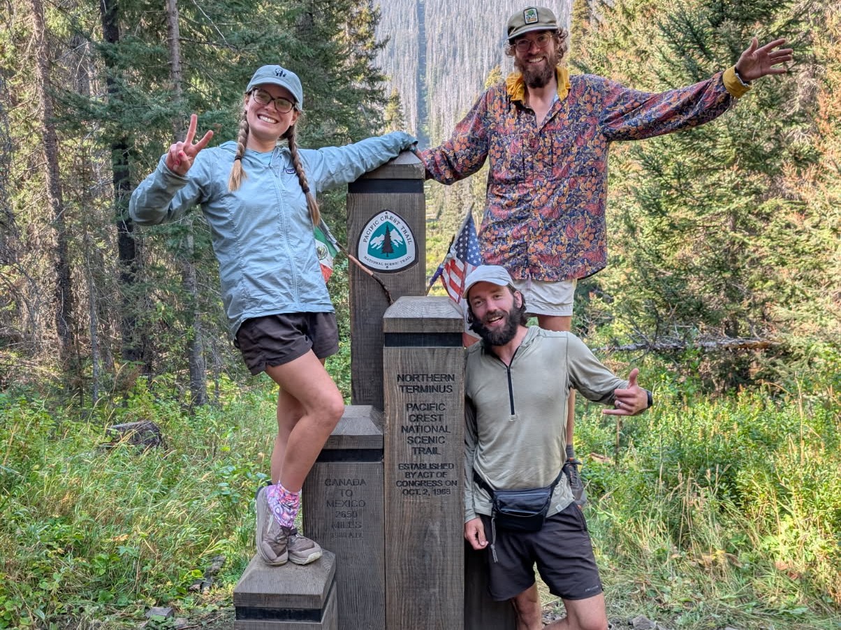
The excitement was there for sure, but the stretch of trail leading to the northern terminus was not particularly special. The final 6 miles to the border went by just like any of the other 2,649. I think we were debating which state was the cutoff of the Midwestern US. Then, we saw a stone monument in the middle of the woods.

At 9:30am on 9/12/2025, Spout and I completed our thru-hike of the Pacific Crest Trail.

Jukebox was sleeping in the weeds about ten yards from the border. He woke up to finally finish his own hike, then joined us in a celebratory border beer. We stayed at the monument for over three hours, as one by one, other hikers began trickling in. 100 Grand, Stag, and Ass Cactus arrived after an hour or so, then Pivot and Greenlight, then Doc and Snapshot, and finally Happy Meal and Footlocker.

The border itself felt completely arbitrary. Aside from being the 49th parallel, it pretty much was. A strip of trees was cut out between the nations that you could easily walk through. Everyone was obviously excited to take a poop in Canada.

Nobody wanted to acknowledge that we still needed to turn around and hike 30 miles back to the nearest road at Hart’s Pass. The folks carrying a Garmin inReach flirted with the idea of pressing the SOS button to get a helicopter ride out of there. Ultimately though, we simply turned around and began hiking southbound on the PCT.

The emotions hit stronger after leaving the terminus. Suddenly, we were the ones on the victory lap. It was beautiful to pass northbound hikers a few short miles from an unbelievable achievement. Everyone had a smile on their face. The views were outstanding. It was wonderful.

We passed LP and Spy, a duo who seemed completely transformed by the thru-hike. Early on, Spy was protected with a hard, corporate shell. He had an entirely new energy about him now, like he had just rediscovered a childlike joy. He told us we had a big impact on him during the few days we hiked together in the desert. Spout and I were teary eyed as we walked away and only hope he can bring that positivity back to the real world after it was all said and done.

We soaked in our last views, said goodbye to friends we would likely never see again, and welcomed an old existential thought: the parallel between a long distance trail and our own lifetimes. These massive endeavors always feel like they will never end, the same way a kid might feel they will be young forever. When the five month journey inevitably concluded, it was a sobering reminder to cherish our remaining time alive.

People are constantly changing and cycling between new phases of life. A thru-hike is unique because these eras of our lives rarely have such a definite start and end date. From April 20 until September 12, my entire life was hiking. Thinking about what came next was like staring through a foggy window.

When we finished the AT, I felt some dread in the possibility I would never do anything as grand or exciting ever again. Now, even though this adventure just concluded, I knew that would not be the case. What brought me comfort was that I had my amazing wife, Spout, at my side, the only person I knew who out-dreamed me on a regular basis.

Together, we hiked to the bottom of Holman Pass. The sun slipped behind the mountains and we pitched our tent on a lumpy space near a trail junction. Greenlight and Pivot showed up later, making a ruckus. We fell asleep in woods, one last time.
9/13 – Day 147 (Bonus Day)
13.5 miles from Holman Pass to Harts Pass
Our final morning camping on trail was pleasant. Like every other day on the PCT, the weather was perfect. The flood of emotions continued as we started hiking at 8:00am.


It did feel a bit more tedious to still be hiking at this point, but it was a good opportunity to process everything. More friends came trekking northbound, including NTS, one of the first hikers we met on trail, and Otis. Later, we passed Altitude, Ducky, and Spike.

At 12:00pm on 12/13/2025, Spout and I returned to Harts Pass and decided to quit our southbound thru-hike attempt of the Pacific Crest Trail. It was time to go home.

There was some world class trail magic setup by the parking lot, but the trail angel was missing. With not much else going on, we were ready to start the 4 hour journey to Seattle. Typically, this would involve a multi-part hitch to Mazama, WA, but we were fortunate to be offered a lift by Greenlight’s parents. Pivot and Doc were also along for the ride.

Karen, Dave, and their son Sean, “Greenlight”, were unbelievably kind. Not only did they give us a ride, they gave us the full tour. Stop one was at the Mazama Bakery for some delicious pastries, focaccia, and salted baguettes. Then, we drove back through North Cascades National Park and pulled off to admire the aquamarine-colored, Diablo Lake.

A few hours later, we arrived at Karen and Dave’s home in Everett, WA. They graciously offered to host us for the next two nights, and Greenlight even let Spout and I sleep in his childhood bedroom. They were a wonderful family and it was great to get to know them over pizza and a Seattle Mariners game on TV.
9/14 – Day 148 (Bonus Day)
0 miles in Seattle, WA
We spent our previous day in Seattle as tourists visiting the highlights. Today, with Greenlight as our guide, we felt like locals. There was authentic Seattle weather too: rain and fog. Greenlight provided us with some fashionable sports attire and we left their house to take the Sounder Train from the Everett Station south along the Puget Sound into Seattle.

We hopped off the train and took the light rail line to T-Mobile Stadium. After a drink at the baseball dive bar, Sluggers, we went into the stadium to watch the Seattle Mariners play the Los Angeles Angels.

The game was an 11-2 blowout by the home team, with plenty of exciting moments. The home run derby champion, Cal Raleigh (“Big Dumper”), shot a missile out of the park on the very first pitch he saw. Value beers only cost $8 in the park, so we had a great time watching the Mariners stomp on LA.

It was Ass Cactus’ birthday, so basically every PCT thru-hiker in Seattle met up to celebrate at Bale Breaker. Vibes were immaculate and good beer was never so rightfully earned. We migrated through the neighborhood of Ballard a few more times throughout the night, first to the Tin Hat bar, then to Kangaroo and Kiwi, and finally a drunk meal at Dick’s Drive-in.

When it was time to stand up and say goodbye to everyone, the floodgates opened. Reaching the monument was not the end of the trail. Returning to Hart’s Pass was not the end of the trail. The moment you say goodbye to the friends you made along the way, that was the end of the trail.

So, that was it. We hailed a ride back towards Greenlight’s place to crash one more night. The next morning, we found ourselves on a plane headed to Las Vegas, NV. As if one last nod to adventure, our plane flew above Mt. Rainier, awe-inspiring and unfathomably huge. As smooth as a spirit’s wing, we soared away from the pacific crest into an unknown future.

What’s Next?
CDT SoBo 2027. Everyone’s invited. We are going south.
Food & Resupply
Favorite food during the thru-hike:
- Peanut Butter M&M’s
- The king of high calorie snacking. During short breaks, I would slam several handfuls of these to inject an easy 500 calories. They also taste delicious.
- Dehydrated refried beans
- My favorite dinner was either Sevilla or Mexicali Rose brand beans, wrapped in a tortilla, with Fritos crumbled on top. Delicious and much more nutritious than potatoes or ramen.
- Bobo’s oat bars
- Oatmeal in bar form, perfect for breakfast on the go. Nearly all varieties of Bobo’s are great, especially the stuffed oat bars and PB&J’s. The protein bars, however, were the worst food I ate on trail.
- ProBars
- A high calorie bar with natural ingredients and tastes pretty good. Plus they have a fair amount of protein.
- Albanese gummy bears
- Dethroning Sour Patch Kids, these bears were my favorite gummy candy on trail.
Gear Changes
Notable gear destroyed or replaced during the thru-hike:
- 4 pairs of shoes (Altra Lone Peak 9+)
- 2 sun hoodies (Duckworth Vapor)
- The merino wool stretched out during the hike, thinning to the point where it offered no sun protection
- 8 (or more) Smartwater bottles
- Evolved Supply Co Ranger
- This backpack held up nicely along the seams, but the back panel has a significant tear
Favorite gear during the thru-hike:
- Double quilt (20° Enlightened Equipment Accomplice) and sleeping pad (Exped Synmat Duo)
- The couples sleeping system we used was well worth the transition. It was so comfortable and easy to regulate temperature
- Alpha direct (Senchi hoodie) and wind shirt (Patagonia Houdini)
- This simple layering system provided more than enough warmth. A puffy jacket was not necessary to carry at all.
- LiteAF fanny pack
- The most practical and convenient piece of gear I own. It typically held my phone, lighter, pocket knife, sunglasses, sunscreen, headphones, and wallet. Sometimes, I would carry bug spray or a bug head net.
- PadPal pad inflator
- So tiny, fast, and saved us so much effort every night inflating our sleeping pad.
- Dual Nitecore 10,000mAh batteries
- I added the second battery once Nitecore sent me a replacement. Though the 2nd battery was somewhat defective, it was still enough for 1.5 phone charges. Having 2×10,000mAh of charging capacity was not strictly necessary, however it was absolutely worth the peace of mind of not having to worry about any of my device dying.
- Long pants (Patagonia Terrebone Joggers)
- I switched from shorts to pants in the Sierra so I could glissade safely. I ended up wearing them for over half of the hike because of protection from the sun, protection from mosquitos, and protection from overgrowth. Long pants are almost certainly the best choice for the PCT, however I did end up switching back to shorts for Washington.
Notes
We successfully connected a continuous footpath for our PCT thru-hike, with very little divergence from the “official route” beyond preferable alternatives. Notable alternates that we took include:
- San Jacinto summit
- Road walk near Castle Crags
- Crater Lake Rim Trail
- Ramona Falls Trail
- Eagle Creek Trail
- Old Snowy summit
- Blowout Mountain summit
2025 was a Goldilocks year for PCT thru-hikers. Those attempting a continuous footpath by road walking in the desert once looked like idiots. Now, those who accomplished it look like badasses. It was only possible with equal parts grit and luck. Notable closures that we faced include:
- Mission Creek trail washout
- Post-Bridge Fire closure near Wrightwood
- Williamson Rock/endangered frog closure near Wrightwood
- Post-Bear Fire, Middle Fork Feather River Canyon detour around severely overgrown section
- Castle Crags State Park Root Creek Basin rehabilitation area outside of Mt. Shasta
I estimate that we walked on fewer than 30 miles of road from Mexico to Canada. Something like this has not been possible for years and may not be possible again for many more to come.
We could not get enough hiking, so we went on plenty of side quests. Despite the PCT length of 2,655 miles, I estimate that we hiked closer to 2,800 miles, factoring in alternates, side trails, and walking around towns. Notable side trails we took include:
- 15 miles out-and-back to climb Mt. Whitney
- 15 miles out-and-back over Kearsarge Pass to Onion Valley Trailhead
- 7 miles out-and-back over Mammoth Pass to Horseshoe Meadows Trailhead
- 20 miles over Clouds Rest from Lake May to Yosemite Valley
- 2 miles out-and-back to Cleetwood Cove in Crater Lake
Other fun stats:
- We finished the PCT in 146 days. This was exactly 1 day fewer than it took us to hike the AT
- Our longest day of hiking was 34.1 miles
- Our average day of hiking (including zeroes) was 18.6 miles
- We averaged 3.6 more miles per day compared to the AT. The PCT is an easy trail in comparison.
- Our longest week of hiking was 181.0 miles
- Our average week of hiking (including zeroes) was 130.0 miles
- We only only took 5 zero days. This excludes 3 days off trail at KMS and 2 days hiking over Kearsarge Pass where we did not make any progress on the actual PCT
- We hiked 19 nearo days (defining a nearo as hiking less than 10 miles)
- I recorded 6,247,268 total steps
- It rained during 20% of our days on trail, however the majority of these rain events were very short or light mistings
- We stayed off trail in a hotel, hostel, or AirBnB 24 times, 16.8% of the days
- We ate some kind of fresh food (i.e. not trail food) on 74 of the days, which is roughly half
- I weighed in at 168lbs after the hike, roughly 5lbs lighter than my starting weight
Thank you to everyone reading this. I am sure my journaling can get a bit repetitive at times (so can hiking). I have made more of an effort to capture thoughts and emotions in an organic way, but quickly learned it is really difficult to transcribe how you feel into words. It is even more difficult to write after hiking 20+ miles while on the brink of falling asleep, but I genuinely loved doing it. This journey was so much more than the scenery and I hope some of that was conveyed through these posts.
An even bigger thank you to Hali and Adam for hosting and supporting us with packages, Jill and Lucy for driving us from KMS to Las Vegas (and back), my parents and brother Tyler for hosting us and flying out to visit, the PCTA, the volunteers, and the countless trail angels who gave us rides, fed us, and/or hosted us on so many occasions.
I genuinely feel like this experience has shown me the very best in people.
Peace & love,
Yeti and Spout
Was as great to follow along the journey for this one as it was for your other entries. You have a real knack for summarizing the day concisely while still highlighting the big moments, as well as the smaller human moments. Plus the photography is fantastic as well (I have the same phone so I have to praise it ;)) If only everyone’s Facebook was like your blog it might be worth logging in once in a while, haha.
Hey Chris! So cool to hear from you and I appreciate the kind words. Some days it felt like absolutely nothing interesting happened at all, while others were jam packed. Just wanted to capture moments that I found interesting.
And yeah I love the Pixel camera. I compared some of my photos to iPhones and Samsungs. The Pixel shots are way less saturated and looked a lot closer to the real landscapes we saw. The 5x zoom is also amazing for nabbing wildlife photos.
Congratulations on finishing!! This was my favorite PCT blog to follow this season. (I followed your link from reddit.) Loved the commentary and the fun games like lake swimming or counting steps. Beautiful photos and really appreciated the energy you brought to this journal.
Thank you, I am so glad you enjoyed reading!
CONGRATULATIONS 💕💕💕👍
I AM SO PROUD OF BOTH OF YOU.
AMAZING. PLEASE KEEP IN TOUCH AND LET ME KNOW YOUR ADDRESS WHEN YOU HAVE ONE🙏
Alex, YOU DID AN AWESOME JOB OF JOURNALING. I HOPE YOU WRITE A BOOK About THIS. THE SUMMARY WAS SUPER GREAT.
HUGS AND LOVE,
GRAM CAROL 💖
Congrats!!!! You guys are amazing. Thoroughly enjoyed following your journey and the 3/10 of a mile I hiked with you in Oregon.
Love you both.
Dad (AKA The Weatherman)