
Spout has been reading about Tara Dower and felt heavily inspired. Of course she did. Last year, Tara smashed the fastest known time of hiking the entire AT in just 40 days. “If Tara can hike 55 miles a day”, Spout proclaimed, “then I can hike 25”.
We are attempting a challenge in the month of July where we must hike 25 miles per day for at least 20 days, “July 20 25s”. By writing this down and posting it on the internet, we now have to do it, or else it will be really embarrassing.
7/1 – Day 73
26.4 miles from Lake Gilmore to the PCT/TRT Junction
July 25s: 1
Waking up early has become increasingly difficult. It is almost as if our bodies are desperately trying to soak up every possible minute of recovery time. The truth, I think, is that we are growing lazy. At 7:00am, we rolled off of our inflatable pad and started the day.


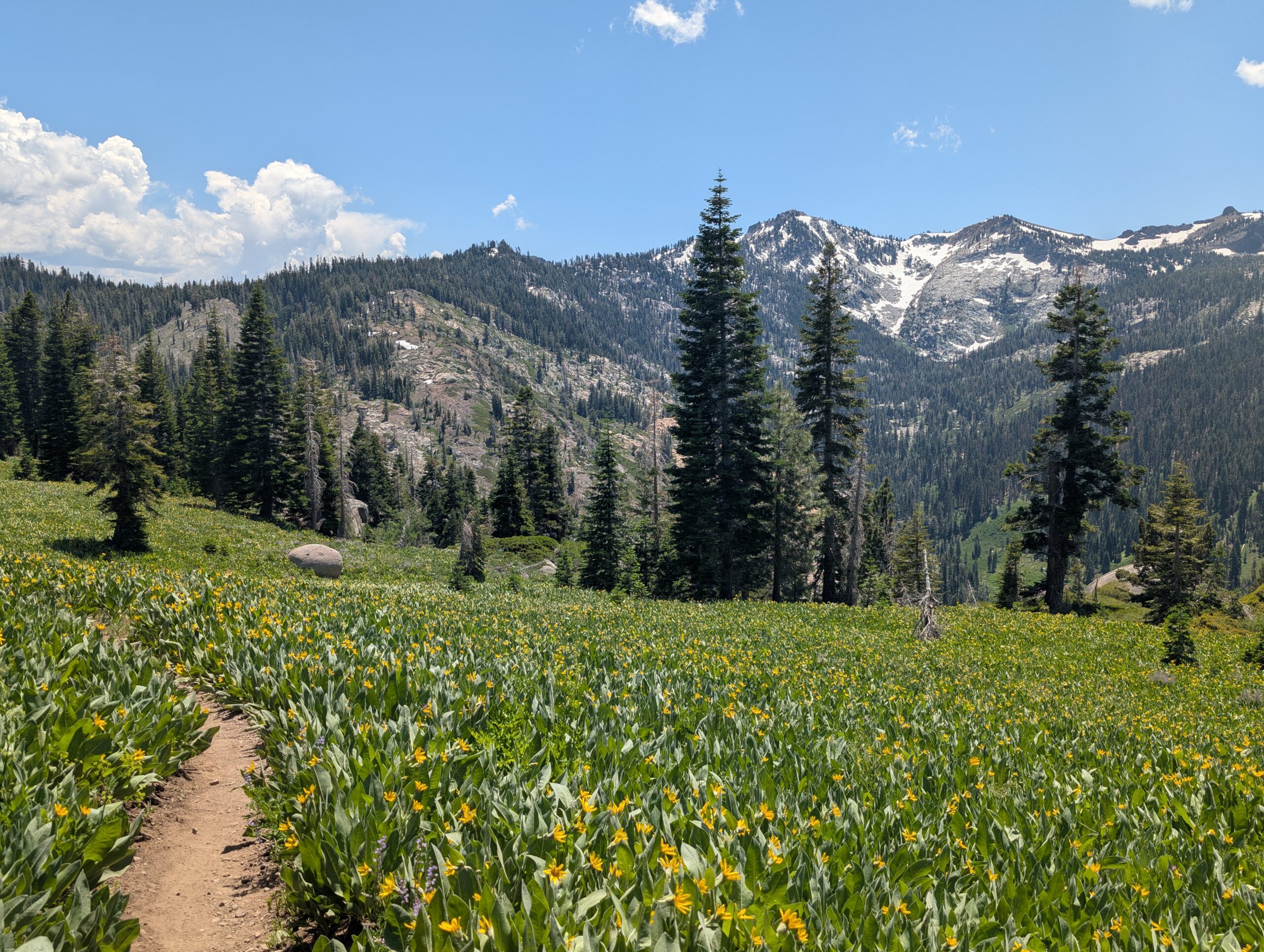
Dick’s Pass was the next obstacle in our way. The terrain was rocky, but the climb was gradual and offered outstanding views of Dick’s Lake and distant mountains. It is really amazing how much a place can change by season and time of day. I remember descending Dick’s Pass during an ethereal September sunset on the TRT. Now, it was bright and sunny, and the surrounding peaks were all covered in snow.

Beyond the pass was the crown jewel of the Desolation Wilderness, Lake Fontanillis. It is a magical swimming hole, but we passed on it this time around. A few other gorgeous lakes followed, including Middle Velma Lake and Richardson Lake on the outer boundary of the Wilderness. We cruised through the nostalgic section at a blistering pace, covering 16 miles before our first real break of the day at 1:30pm.

We ran into Polaroid again at the Barker Pass Trailhead. He started the same day as us (4/20) and we seem to have a nearly identical pace, as we run into each other every few days without fail. As we were chatting in the parking lot, some dark clouds began to gather overhead.

The final miles were an uphill climb on the western rim of Lake Tahoe, providing several glances of the water around Meeks Bay. Thunder rumbled in the near distance and eventually caught up to us, unleashing a short and sweet popup storm. We cleared 25 miles for the day, but there were no immediate campsites, so we had to continue trudging up the hill. Realizing that hiking up to an exposed ridge during a thunderstorm would be a smooth-brained decision, we gathered on the edge of treeline with a few other hikers until the cell had passed. Afterwards, we finished the remainder of the hill and selected a splendid campsite at the top.

Man 3 – 4 Mosquito
This one was a nail-biter, but Mosquito squeaks out the victory with a few well-timed attacks during our water filter breaks.

7/2 – Day 74
25.1 miles from PCT/TRT Junction to Donner Pass
July 25s: 2
In the morning, we were up and moving by 7:30am and left the TRT just a few steps into the hike. Now heading into uncharted territory, we were pleased to find some of the best angles of Lake Tahoe on the northern side.

The themes of today were ski lifts, wildflowers, and ridge walks. Several ski resorts operate around Lake Tahoe and we found ourselves walking past lifts that were likely still in operation just a few weeks ago. We hiked quickly enough over the hills to cover twelve miles by noon.

A pretty flower called Mule’s Ear had completely overtaken every open hillside in the area. If there were no trees, there was sure to be a vast field of yellow flowers in bloom. Something about this plant alludes summer time energy.

There were a handful of modest climbs, always providing a suitable reward of a stunning snow-capped landscape. Tinker Knob and the surrounding cliffs composed a particularly nice stretch of trail. We received some advice from southbound hikers to avoid an upcoming, sketchy snow traverse by climbing up and over Mt. Lincoln. The detour “trail” was quite steep and not exactly a climb we wanted to make after 20 miles of hiking, but we avoided the ice chute and bagged the ski mountain in the process.

The final challenge was a steep and rocky descent that dragged on for a mile. At the bottom, we finally reached Donner Pass. Once the site of one of the most harrowing tragedies in American history, it was almost ironic to find a major highway and ski resort at the trailhead. We walked a short way down the road to the Donner Ski Ranch.

At the restaurant, I celebrated my 29th birthday with a free 40oz beer, pizza, and slice of chocolate cake! I really could not ask for a better way to spend the day than at the site of my 2nd favorite historical survival story (the 1st, of course, being Sir Ernest Shackleton’s heroic leadership of The Endurance). At least a dozen other hikers including Groot, Wait, 007, Hottub, Carmen San Diego, Uncle, and Otis occupied two tables on the patio and forced me to endure the Happy Birthday Song.

Before the sun had set, Spout and I hit the road and knocked out another mile or two. The 40oz of Bud Light sloshing around my brain made it feel like I just floated right on down the path. Fortunately, both Spout and me were stuffed, so we did not have to worry about one of us growing a little too hungry… After making camp, I slept restlessly under the indifferent stars above.

Man 4 – 4 Mosquito
A birthday wish come true, there were virtually zero mosquitos today. Man gets a point.
7/3 – Day 75
26.7 miles from Donner Pass to Lasier Meadows
July 25s: 3
When you stumble upon a grimy pit toilet at a trailhead, it is like randomly finding $20 in your pocket. When you stumble upon the I-80 rest area, it is like winning the lottery. Flushing toilets, trash cans, and a water fountain awaited us at the Donner Pass rest stop, just two miles into our daily hike.


Beyond the road, the elevation profile was a series of six rolling hills. The uphills are hardly worth mentioning anymore, as the grade is so forgiving we can handle them in stride. With snow patches becoming less and less frequent, we are simply unperturbed. I fear the Sierras have turned us into monsters; monsters that devour miles and have extraordinarily sexy calves.

The landscape has been consistently pleasant. While not quite as dramatic as the higher peaks we recently cleared, it was beautiful nonetheless. The abundant Mule’s Ear seems to be the calling card of this section. Just about every exposed hillside involves strolling through the pretty, yellow flowers.

To pass the time while hiking, Spout and I discussed family matters, politics, or ambitions. Where will we go after the hike? What will we do? Thru-hiking always provides more questions than answers. There is a subtle frustration that brews when you contemplate big plans for months but cannot act on any of them.

Despite another long day, we did not feel particularly strained. After crossing a dirt road, we found a flat spot to throw our tent among a sparse collection of pine trees.

Man 5 – 4 Mosquito
Mosquitos cannot handle the wind along the ridges, they were nowhere to be seen yet again. Score one for the good guys.

7/4 – Day 76
13.9 miles from Lasier Meadows to Sierra City (Sierra Country Store)
July 25s: 3
The trail to Sierra City was mostly downhill and not particularly eventful. We made a quick stop at the Pass Creek Campground, but otherwise let our minds wander as we trekked ahead to the next small town. Once at the road, we chose to hitch to the Sierra Country Store instead of making the mile and a half walk.

The store had a patio for hikers and enough food for Spout and me to happily gorge ourselves. We spent several hours hanging out with the hiker trash, then walked further down the road to Sierra Pines Resort 4th of July celebration. The live musician stopped playing when we showed up so he could commentate several rounds of potato sack races for the families. Though the town seemed to love hikers and wanted all of us in attendance to compete, there was no way I was going to risk straining a hip while hopping around in a sack.

Small towns out west do not shoot off fireworks because of wildfire potential. It felt like some of the magic was missing without the crackle and pop of explosions all around us once the evening arrived. Instead, we went to the Old Sierra Hotel and spent the night among a motley crowd by the bar. The owners made everyone dinner for free and it was a cool environment. We posted up for the night on the patio of the country store behind the dumpster. Neither of us slept very well, but it sure was a great day to be free.

Man 6 – 4 Mosquito
Mosquitos take the L like the British in 1776.
Happy 4th of July! I made the mistake of checking the news and saw the Trump administration attempting to push the “Big Beautiful Bill” that would, among other things, sell off millions of acres of federal land. We are lucky to live in the most beautiful country in the world, and anyone who claims to love the outdoors, camps, hikes, climbs, skis, fishes, hunts, paddles, or recreates outside in any way ought to be outraged that the government feels entitled to sell off our land for profit. The only explanation for this attempted sale is greed, plain and simple. Some things are more important than money and once our land is sold, it is gone for good. The PCT is not for sale.
Fortunately this clause was removed from the bill. Realistically, however, the GOP will continue trying to sell off federal land. In 2016, Trump reduced the size of Bear Ears National Monument by 85%. Under private ownership, that land will be destroyed in pursuit of resources, or perhaps paved over to make space for strip malls.
When Trump inevitably succeeds, it will be a truly sad day for America. The Appalachian Trail and Pacific Crest Trail would not exist if they were not dubbed National Scenic Trails and protected by legislation. In addition, all of our National Parks, National Forests, and National Monuments benefit from similar protection. It should not matter if there is billions of dollars worth of oil under these wilderness areas. Our planet is a gift from God that should be protected at all costs. True patriots should protect our land, not destroy it.
7/5 – Day 77
25.8 miles from Sierra City to McRae Ridge
July 25s: 4
After the screaming children across the street went to bed (had to be after 1:00am), I finally got some sleep. Spout woke me up an hour after sunrise and we cleared the area. Before heading out, we ate a mediocre breakfast at the Red Moose, along with a hiker from New Zealand named Hush.


We hitched back to the trail and started the hike around 9:30am. When it comes to attempting to hike 25 miles in a day, starting this late is not a great strategy. We generally travel at 3mph pace or slightly faster when the trail is gently graded and smooth, but slow down expectedly on steep climbs and rocky sections. This means we need to be hiking for a minimum of eight hours, excluding breaks, to hit our target. The climb out of Sierra City was not overly steep, but involved a punishing, 7.5 miles of steady uphill.

We shortened our breaks to improve productivity. A snack or two was enjoyed at the top of the Sierra Buttes junction, then again at the Packsaddle Campground. The scenery along the PCT is regularly so dramatic that when it is even a little bit understated, I feel unimpressed. Still, there were plenty of great views of Tamarack Lake and a handful of others that drew crowds of hikers to the nearby campgrounds.

Spout and I continued rolling through the afternoon. There were still a few unexpected snow patches that refused to die. Otherwise, the terrain was manageable. After twenty miles, we ate dinner on trail and pushed ahead through golden hour. It was a beautiful and serene evening through the flower fields.

The site we were eyeing up at exactly 25 miles in was packed full of tents already, so we were forced to continue hiking until 9:00pm when we found a suitable area on the saddle of McRae Ridge.

Man 7 – 4 Mosquito
No bugs to report. I think they are throwing.

7/6 – Day 78
29.2 miles from McRae Ridge to Middle Fork Feather River
July 25s: 5
Spout and I are likely in the minority of hikers who attempt 30s after sleeping in past 7:30am. With an elevation profile that heavily favored downhill, it was a possibility. A few fast paced miles had us well on our way. We skirted several peaks including Beartrap Mountain, Stafford Mountain, and Mt. Etna.

Typically, Spout and I always keep within eyesight of each other while we hike. Since we share a sleeping system together, it is pretty important to make sure we do not split up often. I took the lead climbing a hill that intersected a dirt road halfway up. A wrong turn had me following the dirt road for a quarter mile. When I realized, I bush-whacked to rejoin the red line. The problem was that I could not see if Spout was following me or if she took the correct route and passed me. If I stood waiting, she might find herself far ahead in thirty minutes. If I ran ahead to catch her and she was actually behind me, I would be far ahead. It was an annoying problem, especially because Spout would probably continue to assume I’m waiting somewhere ahead. I guessed correctly that she had passed me, then jogged to catch up, surprising her by somehow teleporting behind.

At length, we reached a burn zone, the first significant post-wildfire section of northern California. Beyond just putting a damper on the scenery, burn zones also provide no shade, little water, and potentially dangerous camping due to widow-makers. We took it in stride, and cruised past twenty miles within the forest of burnt matchsticks.

There was an upcoming stretch of 7 miles that had not been maintained in years since the fire. According to posted warnings, the final few miles were borderline impassible due to severe overgrowth and blowdowns. As advised, we followed a detour along a dirt road that added distance to our itinerary, but probably saved us quite a bit of time. Though we were ready to call it for the day, camping anywhere in this section meant we would be sleeping under dead trees ready to fall over at any moment. Occasionally, we would hear large sticks fall off the trees at random intervals.

Towards the end of the road walk, a man with nothing but the clothes on his body passed us heading the opposite direction. He told us a disjointed story about how he fell into a confluence of the Feather River, had not eaten anything in two days, and just needed a swig of water before he made it back to his car. It did not really line up, but I left him with a full bottle of water and as many protein bars as I could spare.

It was growing dark by time we reconnected with the PCT to begin a 2 mile descent to the Feather River. There were well over a hundred trees fallen across the trail. The difficulty of hurdles was exasperated with our headlamps being the only source of light. Mentally, we were completely resigned and desperate to drop our tent at the next possible opportunity. After the crossing the bridge over the Feather River, we found an excellent campsite near the water among live trees.

Man 8 – 4 Mosquito
Turns out mosquitos do not like scorched Earth any more than man. They were not a problem today.
7/7 – Day 79
18.1 miles from Middle Fork Feather River to Bucks Lake Road (Quincy, CA)
July 25s: 5
Along the bank of the Feather River, we found ourselves below 3,000′ in elevation for the first time on the PCT since the LA aqueduct. This meant we could finally drink water while hiking without running out of breath, but also meant the summer heat was ramping up. This was another area still scarred from wildfires, so the shade was spotty at best. The climb up from the water was a 10 mile, 3,000′ ramp that took us through the afternoon to complete.


At the top, we made it to Lookout Rock, a cliff with a sweeping view of the mountainous landscape we just traversed. After a short lunch, we were determined to hike the next 8 miles to the road as quickly as possible. It had been a week since we showered or washed clothes, and both agreed this was the most disgusting we have felt on the trail so far. Maybe it was the heat, or the ash covered ground, or the higher humidity among the overgrowth. In any case, we smelled like straight ass.

The trail was mostly flat from here, and the blowdowns conveniently vanished. A few sub-17 minute miles had us at Bucks Lake Road before 4:45pm. It was a tough hitch that took us over an hour before a trail angel, Turk, dropped off another hiker and offered us a ride into Quincy, CA. We coordinated with another trail angel, Pounder, for a place to stay the night. I am so grateful for those who dedicate their time and energy to the trail. None of this would be possible without them.

Before settling in, we grabbed sandwiches and shakes at The Polka Dot with Altitude, Spike, and Ducky. Then, we bought some groceries for later and went to Pounder’s house. The host and a number of other hikers were playing Mexican Train in the living room. After sterilizing myself, I joined in for a couple of rounds while Spout made a flag cake for everyone in the shape of the PCT logo. Later that night, we pitched our tent in the yard.

Man 9 – 4 Mosquito
Man is running away with it. Mosquitos are nowhere to be found in the burn areas.

7/8 – Day 80
12.3 miles from Bucks Lake Road to Bracken Fern Spring
July 25s: 5
Everyone, including Pounder, left early in the morning, so Spout and I made breakfast by ourselves. The meal consisted of a dozen eggs, one huge avocado, and a handful of spring mix. We cleaned up the house a little bit, then walked to Sav-Mor to resupply.

We hitched with a man in his old, 1970s Ford truck to shoot across town to the hardware store for stove fuel. Then we stopped at the post office to mail home some gear, and finally Midtown Coffee as a reward. In no rush to leave, we used the morning for a chance to get to know Quincy. The locals everywhere we visited were extremely friendly, such as the owners of the Toy Store who gave out free ice cream for hikers. As we were sitting outside of the food co-op, just about ready to start hitching back to trail, Turk pulled up to grab a cookie and offered us another ride.

“It is not transactional”, Turk explained to us on the drive back to Bucks Summit. He really just wanted to help out. The funny thing about receiving a gift is that it always seems more important to give back, though he would not accept even $10 for gas. Maybe in a community where everyone contributes without expectation, reciprocity would flourish. We would consume less and be more grateful for everything we already have.

We were back on the PCT around 3:30pm. A gentle, four mile climb was waiting for us. From there, the trail followed a ridge through a mixed bag of trees, some clearly charred while others were green and flourishing. We both felt fully refreshed and enjoyed every step of the hike. As always, it is amazing what a hot meal and a shower can do to for a couple of tired souls.

Eventually, we exited the treeline onto an exposed portion of the ridge and came to an outstanding campsite. Some of the finest views of NorCal could be seen in either direction. The were no bugs and only a slight breeze to accompany the colorful sunset.
Man 10 – 4 Mosquito
With yet another point for Man, this experiment is a wrap. Man wins convincingly and Mosquito truthers are in shambles. Perhaps when we are in Oregon, Mosquito may challenge us once more, but for now it looks like they are in retreat.
What’s Next?
The Dixie Fire of 2021 burned a massive stretch of the PCT and surrounding areas. We continue hiking north through this burn area into Belden, CA, Chester, CA, and Lassen Volcanic National Park.
How’s It Going?
We are likely as primed for hiking as we will ever be on this hike. We both feel like our legs are strong and lung capacity is near infinite, especially as the elevation continues to drop. Long days are still difficult though, because of low energy or mental fatigue.
Blisters are not really an issue, but I have developed ridiculously thick calluses on my heels. Spout has a problem with painful, red skin on her foot.
Food & Resupply
In northern California, the PCT travels through towns and crosses roads much more frequently than the Sierra (and even the desert). This means we can make do with shorter food carries of 2-4 days and carry basically whatever we want.

Albanese gummy bears are, as advertised, the world’s best. They blow all other brands out of the water and have become our candy of choice on trail. Spout and I will typically split a 2.5lb family size bag for a 4 day resupply.

Gear Changes
- We both sent home our bear cans. Even though bear cans are required for camping in Lassen Volcanic National Park, we can hike 19 miles through the park in one day, or camp at an established campground with bear lockers to get around this
- We both sent home our puffy jackets
- Spout sent home her MICROspikes
Notes
- There are several wildfires burning north of us on or near the PCT. The Summit Fire and Green Fire are two in northern California we are monitoring
- WatchDuty app is the best source for fire info
You two are really moving fast!! 25 miles daily ! Wow! I get so much enjoyment reading your posts. Hope you write a book after completing the PCT💝Love you!! Gram Carol