
4/28 – Day 9
20.2 miles from Dispersed Campsite to Highway 74
We have formed a bit of a routine in waking up reasonably early, but I’m not sure how long it will last. I was stirring by 6:20am and we collapsed our tent and started hiking less than an hour later. There were a few lingering clouds, but the forecast was clear and sunny with a high of 66°.


Spout and I consumed some caffeine that wired us into hiking machines. We cleared the morning mileage efficiently, stopping for a breather and a snack on top of a concrete cistern. It was here that Spout finally had to wander off and dig her first cathole of the hike, after making it an impressive 140 miles using only toilets.

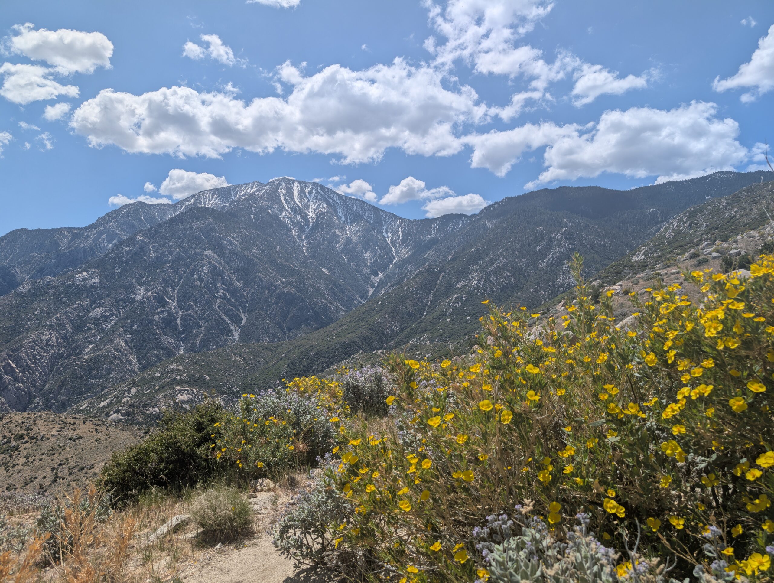
The landscape today featured more rolling hillsides with spotty brush and cacti. We hadn’t seen Mt. San Jacinto in a few days, due to the clouds, and we kept searching throughout the morning. Our blistering pace continued and we nearly covered 14 miles before a brief lunch break at noon.

We hiked 20 miles to reach Highway 74 around 3:00pm. Possibly a bit too fast, as my feet were starting to scream at me. This road was about 17 miles away from Idyllwild, CA, a trail town at the base of Mt. San Jacinto that most hikers access 30 miles further north. However, we needed to hitch into town to pick up a permit and resupply food for two more days. It took less than 10 minutes to score a ride from a friendly court reporter.

We went to the ranger station and filled out a free permit for the San Jacinto Wilderness, then walked over to Atomic Cow for fantastic smash burgers and huckleberry milkshakes. Lastly, a quick resupply at the Village Market, whose stock had been rummaged by a bubble of hikers that came through a few days before.

We tried to hitch back to trail and were offered a ride by a guy named Hector, who owns the plant nursery in town. He was incredibly laid-back and gave us a tour of the nursery that he recently bought. His favorite plant was a sage named Greg and would do all kinds of silly things, like point to where it wanted to be moved within the nursery.

He dropped us off and we tossed him some gas money. We made camp just a few hundred feet from the road in an open field, strategically setting ourselves up for a breakfast at Paradise Valley Cafe the next morning before another long day of hiking.

4/29 – Day 10
16.7 miles from Highway 74 to Spitler Peak
Camping in the open field broke every rule of good campsite selection, and we paid the price with another wet morning. The excessive condensation is certainly something I did not expect to be an issue in the desert. Spout and I devised a plan to leave our tent setup with everything inside, then hike to Paradise Valley Cafe for breakfast. We hoped it would dry by time we returned.

The cafe did not open until 8:00am. There were a half dozen hikers who had slept on the porch now stirring when we arrived. A big breakfast and hot coffee go a long in way in fueling a hike, but do they offset a two mile round trip road walk? I’m genuinely torn; this could be the ultimate hiker’s dilemma.

Fortunately, our plan worked and after packing up our toasty dry gear, we started up the trail. Initially, it seemed it was going to be a scorching hot day but after the first handful of miles, clouds came to the rescue. The trail took us past some zany rock formations in the afternoon.

Water in the San Jacinto Wilderness was scarce, and we soon reached a second dilemma on which of two side trails to take to fill up our bottles: 1/4 mile down a steep hill, or 1 mile down a gradual hill. We chose the former, but the catch was that the spring we chose had a strong sulfur taste. It was perfectly safe to drink, but had a feint aftertaste of raw eggs.

The trail continued its climb towards Mt. San Jacinto and we soon broke 7,000′ in elevation. For comparison, this is greater than the highpoint of the entire AT at 6,643′. We also started noticing small patches of snow on the trail. The views opened up towards Apache Peak and the scenery was absolutely stunning. The miles were slower going than usual and it honestly felt like this was the first true climb of the entire trail.

After one last push near Spitler Peak, we found a protected campsite out of the wind, with sweeping views to both the west and the east. It was the perfect place to catch a beautiful sunset and wind down before bed.

4/30 – Day 11
10.9 miles from Spitler Peak to Idyllwild (Strawberry Creek Inn)
I brewed a pot of coffee in our tent vestibule as the sun rose. I believe this was the first time in my life where I watched the sunset and sunrise from the same location. It was beautiful. I think normal people call enjoying simple outdoor pleasures like this, “camping”, and it’s a damn good time.


Today’s hike was the most challenging we have faced yet, but we were treated to epic views every step of the way. The climbing continued along Mt. San Jacinto and we encountered a section with heavy blow downs. After skirting Apache Peak, we crossed a rock slide section that would have been seriously treacherous just a few weeks ago. Then, as we cracked 8’000′, the terrain transitioned to a high alpine evergreen forest.

The snow was mostly melted at this point in April, and we did not regret leaving our MICROspikes at home. However, we did cross several small patches. At length, we came upon Taquitz Creek which provided delicious, ice cold snow melt that tasted like the nectar of the Gods compared to the egg water we had been drinking.

I tried, and failed, to bag Taquitz Peak, finding out a few hundred yards up the side trail that there was still excessive snow coverage. Instead, we continued pushing ahead to Saddle Junction. Turning left to descend Devil’s Slide Trail took us 2.5 miles downhill to a parking lot where Spout stuck a thumb out for a ride.

Two women offered to drive us into town and were exceedingly generous, giving us their numbers if we needed a ride to Cabazon later, and then, despite our protests, left us with some cash. We felt it would be best to pay it forward, and helped a fellow hiker, Cheyenne, fund new insoles to address her IT band pain that had forced her off trail.

Idyllwild has become one of my favorite small towns and I cannot say enough about how amazing the people are. Every interaction we had with the locals was genuine. The rustic setting of the town at the base of Mt. San Jacinto was amazing, the food was excellent, and there were so many unique shops. It was expensive for sure, but we felt genuine support towards hikers and overwhelming positivity.

We checked into the Strawberry Creek Inn and enjoyed our first proper showers and laundry of the hike. We did plenty of town chores, resupplied for five days, picked up a $28 pizza that was not very big, and brought some beer back to the cabin. We sat on the porch and shot the shit with another hiker named Jonathan. Afterwards, we fell asleep watching Toy Story in a cozy king-sized bed.

5/1 – Day 12
8.1 miles from Saddle Junction to Fuller Ridge
The best part of a thru-hike is that every so often, you’ll experience what feels like a perfect day. Sometimes it’s obvious ones, like when I proposed to Spout in the Grayson Highlands or when we summited Katahdin. Other times, it’s random days that just feel packed with amazing little moments. I certainly didn’t expect much after waking up with a bit of a dull headache.

Feeling fully recharged, we packed up, then grabbed coffee and bagels from Raven Hill Bagels, falling into a lengthy conversation with Asa and Traffic Cone in the process. Around 10:00am, we hitched back to trail, pulling over the first car. Nathan was yet another beacon of positivity who called both Idyllwild and his renovated Ford Transit “home”. Our conversation with him was brief, but the sincerity was apparent and both Spout and me felt strangely emotional as he dropped us off at the bottom of the Devil’s Slide Trail.

We made the two mile climb back to the PCT. At Saddle Junction, we met another new hiker, 4-runner, who essentially gave Spout the confidence to attempt climbing San Jacinto Peak. She was nervous to attempt it without spikes, due to her fear of sliding and the reports of heavy snow near the summit. What she needed was to hear a badass, fifty-year-old cancer survivor shrug off the apparent danger.

Two miles north of Saddle Junction, the San Jacinto Peak Trail split from the PCT. Alongside Forerunner, we made the steady climb up some 3,000′ in elevation to bag the peak. Exactly three years from when Spout and I started north from Springer Mountain on the AT, we stood proudly on top of San Jacinto Peak.

It was a clear day and the view did not disappoint. To the north, we saw Mt. San Gorgonio. To the east, the city of Palm Springs, CA. In every other direction, the jagged, snow-covered crests of the mountain we had just conquered. Forerunner passed around a summit beer to celebrate and despite only knowing him for a few hours, he felt like a lifelong friend.

The descent was just a bit tedious and we slid along much greater quantities of snow, losing the trail a couple of times. However, no section felt unsafe and falling was almost entirely inconsequential. Shuffling through the slush, we eventually made it back to the PCT, breathed a sigh of relief, then turned right to follow Fuller Ridge. In total, the alternate replaced about 4.5 miles of the PCT with 6 miles up-and-over the summit.

After another mile or two of hiking the ridge, we decided to call it for the day. The daily mileage we logged did not reflect the effort expended on the summit, but today was easily my favorite day on trail yet. To cap it off, we ate dinner with Cache and Allie, who managed to snag a bottle of Woodford Reserve from a hiker box in town. We shared some whiskey on the ridge, realizing at that moment, there wasn’t another place in the world we would rather be.
5/2 – Day 13
18.2 miles from Fuller Ridge to Large Rusted Pipe
On deck today was a massive, 7,000′ descent that would take us off Mt. San Jacinto and into the valley. However, we first needed to complete the remaining two miles across Fuller Ridge, which proved to be the most technical, snow-covered section of the PCT thus far. Spout has conquered her fear and even commented that sliding across the snow was enjoyable and gave her something to focus on.


The descent began as a beautiful, gently graded stroll down the mountain. Wildflowers accounting for nearly every color of the rainbow were blooming along the way, and we encountered new species as the elevation continued to drop. The novelty eventually wore off, however, considering this grueling 20 mile descent was the longest of the entire PCT. There was very little shade and the sun cooked us at 85° from all sides as we twisted and turned along the switchbacks.

Cacti started popping up again below 5,000′ or so, and it was hard to believe that just a few hours earlier we were trudging across snow. Below us, we inched ever closer to Whitewater, Highway i-10, and a field of windmills that spun around and around, mockingly. We donated a liter of water to a hiker who had neglected to fill up water at the previous stream and was surely dehydrated.

We passed the 200 mile marker, then came upon the legendary, “Large Rusted Pipe”, which has become a meme in FarOut for its questionable inclusion as a waypoint. I was personally very impressed by both its length and its rustiness, however its girth left some to be desired.

Just beyond the pipe was a water spigot next to a paved road. We could not really hike any further or else we would end up camping in the valley, which was a literal wind farm. Hoping to avoid another sleepless disaster, we pitched in a dried river bed, protected from the elements.


5/3 – Day 14
22.4 miles from Large Rusted Pipe to Mission Creek
In the morning, I ate my usual, quick trail breakfast of a pastry and an energy bar as we hiked down the road and into the sandy flats approaching i-10. The four miles were long, boring, and windy. Each step demanded just a bit more power through the heel to overcome the loose sand.

After crossing under the road, we made a short detour to Hiker’s Haven Hostel. This was literally just a woman’s house packed with hikers. However, it was a valuable opportunity to charge up our devices and poop in a real toilet. We left within the hour, eager to get away from the noisy highway and hopefully enter a more interesting wilderness.

Beyond the road were the painted hills of Whitewater, which we spent the afternoon climbing up and down. Mt. San Jacinto still loomed in the rear view mirror, looking more picturesque than ever alongside the rust-colored rocks. We spied the aptly named Whitewater River from the ridge and descended over the course of a few miles.

We hiked a half mile off trail to reach Whitewater Preserve, which was a literal oasis. The entire canyon was otherwise exposed and riddled with white rocks, except this small preserve, exploding with lush growth, koi ponds, and even some palm trees. We enjoyed a shaded lunch under a pavilion. A nice woman even gave us two cans of La Croix and a salad as impromptu trail magic.

We could have sat at the nature preserve all day, but eventually got our butts in gear to make miles. We hiked through another scenic stretch of trail leaving Whitewater. In this section just over a month ago, a hiker had wandered off trail to a precarious ledge, panicked, called SOS, and was rescued by a helicopter. Here is the video.

Mission Creek was the next obstacle in our way. This was a ~10 mile stretch of trail that washed away in a flash flood over a year ago. The trail has yet to be rerouted (partly due to federal budget cuts to our country’s park management). Instead, it has become a choose-your-own-adventure scramble along the riverbed. We expected this section to slow us down, so we knocked out the first two miles before sunset, then found a cozy campsite on the shelf in the canyon.

5/4 – Day 15
18.4 miles from Mission Creek to Coon Creek Cabin
We expected the creek to be our greatest challenge of the day. We were wrong. The miles were indeed slower than usual, as we had to carefully select the path of least resistance across the wasteland of rock and sand. Unlike normal hiking, which offers moments of autopilot, this demanded our full attention. Still, both Spout and I found it rather enjoyable. We soon navigated the worst of the washout and found ourselves on an “island” shelf raised between two tributaries of the creek.


In the distance, we saw dark clouds form around Mt. San Gorgonio. Without service to check the forecast, we could only trust what some day hikers had told us the day before: rain was expected, and possible snow above 5,000′. Since the trail climbed towards the mountain and we would be closer to 8,000′ in just a few more miles.

What started as sleet, transitioned to a pelting hail, then compromised to form freezing rain. It did not take very long to realize that these were potentially life threatening conditions if not taken seriously. The wind, rain, and cold temperatures were only getting worse as we climbed along Mission Creek. It was absolutely frigid. Hiding under a tree did not help much, we knew the best decision was to seek refuge in our tent. It was a haphazard pitch, but it kept the water out and the heat in, as we cowered under the tarp.

The rain slowed to a drizzle by 1:00pm. Only two hours of adverse weather was enough to force about a dozen hikers in the area to throw up their tents. I believe we could have very well found ourselves hypothermic had we attempted to hike through it. However, for a brief moment, Mr. Blue Sky was showing his fat, happy smile and it seemed it was going to clear up. We tore down our tent and continued hiking.

We navigated the remainder of the Mission Creek washout over the course of several miles. The trail would sometimes reappear for a mile or two along the hillside, but always seemed to dip back into the creek before long. The rain picked back up eventually, though not nearly as intense, and we made one final scramble up a muddy disaster of a trail before that section was finally behind us.

Since we had not eaten a real lunch, we had a hot bean dinner on trail at around 4:00pm, hoping refried energy would refuel our chilly bones. As we were slurping down our final spoonfuls, we noticed a few snow flurries in the air, but they melted innocently upon reaching the ground. We were excited to say we saw a few cute little flurries, but assumed the bulk of the precipitation was done for the day.

However, the snow kept coming, and coming, and coming. The flakes grew larger, fell faster, and started to stick. We realized that whatever weather forecast we had read meant nothing to these mountains. This was a snowstorm.

It was not long before everything was covered in a few inches of snow, some from the earlier storm no doubt, but just as much fresh powder piling on top. Surprisingly, the snow was not quite as cold as the freezing rain earlier in the day, whether this was due to our recent meal, adrenaline, or something else, I’m not sure. In any case, we managed to trudge six miles through the ever worsening conditions, re-soaking ourselves in the process.

Our tent was not prepared for this weather and I was not sure where we could even find a spot to pitch it, let alone whether it could withstand so much snowfall. There was a cabin marked on our map that we desperately headed towards as it grew darker. Miraculously, it was open and already occupied by a few other hikers, including Punisher and NTS. They had a fire roaring and I’m not sure I’ve ever felt so much relief in my life.


5/5 – Day 16
19.6 miles from Coon Creek Cabin to Big Bear Lake ITH Hostel
Snowfall accumulated several inches overnight. It was hard to force ourselves out of our safe haven and back onto the ski slope that was the PCT. However, we had a much more powerful motivator than temporary warmth, and that was a private room at a hostel in Big Bear Lake. Only a short, 20 mile hike away. We threw on our freezing, wet clothes to hit the trail at 7:00am.

The first handful of miles were the most tedious. It was still snowing, albeit lightly at this point, and we dragged our feet through the six inches of powder along the ridge. We were fortunate to have a fresh boot track to follow, since Punisher had left before us and had already done the dirty work of pathfinding.

We did not care about anything except pushing through the snow as quickly as possible, knowing that the trail would eventually descend to a lower elevation that would (hopefully) be clear. There was nothing to look at, since we were engulfed in a white haze, and there was no reason to stop, since our bodies would cool down and absorb even more snow. Despite a slightly reduced pace, we completed twelve miles by noon without a single break.

Eventually, we dipped below 7,000′ of elevation. The snow became rain, which is objectively worse, but the trail was finally snow-free and our legs were free to resume maximum speed. To our own detriment, we did not stop hiking until we made it all the way to Highway 28, which was our access point into Big Bear Lake, CA.

A trail angel was waiting by the road, ready to help needy hikers with a ride into town. He drove us to the ITH Hostel, where we could finally shed our dirty clothes, shower, and warm up for the night. We celebrated Cinco de Mayo with fajitas at La Bamba, then later grabbed a beer at the Big Bear Brewery. The hostel was great and we met plenty of new hikers and enjoyed a night in sweet, sweet comfort.

What’s Next?
Upcoming is more desert! We are not even half way done yet. The largest desert mountains are behind us, but we are approaching Mt. San Antonio. Soon, we will enter the Angeles National Forest and head directly west towards Los Angeles for a stretch.
How’s It Going?
It does seem that we have entered the phase of enduring random, short-lived injuries that seem serious in the moment. I felt pain along the top of my right foot after our big push towards PVC, but that went away after a day or so. Spout has commented about pain on the bottom of her feet. As I write this, I feel a sharp pain when turning my left ankle, no doubt resulting from our sprint into Big Bear Lake. My belief is that it is important to listen to your body, take it easy if needed, but to not always assume these injuries are here to stay. It is almost like they are growing pains to form trail legs. We have started to consume ibuprofen sparingly, which we did not need to do during the first week.
We still have a very positive outlook on the hike as a whole. This section was a bit of a wake up call of what we should expect in the Sierra. The washout section and bad weather were definitely the greatest challenges we have faced yet, but we are not rattled. If anything, the PCT now feels like a proper adventure.
Food & Resupply
Beans, beans, beans. The best meal you can eat on trail, bar none. Yes, our quilt is effectively a Dutch oven each night. No, it does not bother me (I can’t speak for Spout). We have been mixing about 6oz refried beans with half a package of Knorr rice (rotating flavors), olive oil, and a Cholula packet it we can swing it. This makes a hearty portion that has us fighting over the pot.

For lunch I have been cold soaking couscous and adding olive oil for extra calories. A great hack I just learned is to use a silicone food lid, so my pot can be used as a leak-proof cold soaking container. Couscous rehydrates so quickly that I do not need to bother with putting on the lid, but this will work if I want to cold soak something that takes longer while hiking.

I also try to supplement my lunch with a Complete Cookie slathered with peanut butter. This makes for a delicious, ~800 calorie snack.
Gear Changes
- I ordered a silicone food lid for my pot
- Somehow, both Spout and I lost our 6″ USB-C cables, so we replaced them
Notes
- I have received several suggestions for a new trail name from hikers, including Detour (because I’m always taking side trips), Sunshine (because I commented that only women get the trail name Sunshine), and most recently, Yeti (because Spout says I’m always playing in the snow and I’m like a human furnace). I’m letting them stew for a while, but I’ll settle on something soon.
- We were not totally unprepared for the snow storm. We had received forecasts from other hikers with Garmin satellite weather updates, however they said only 1mm of new precipitation was expected and it would blow over!
- Since the San Jacinto Wilderness is now cleared, we no longer have to worry about any sections that require a permit until Kennedy Meadows. We have printed out our PCT long distance permit and it will be active by the time we need it.
Wow! Watch the video of the rescue! A Lucky Lady!!! Hope you are warmed up and cozied up by now. ,,🙏🙏🙏🙏🙏Love you 💕💕