
6/1 – Day 43
4.5 miles from Kennedy Meadows to South Fork Kern River
It was time to escape the desert once and for all, which first meant leaving Las Vegas. Spout and I were outfitted with fresh shoes, long pants, and a slew of new toys in our packs. We shoved them in the trunk of the car, and our same crew of Jillian, Lucy, Spout and myself sped off towards the mountains.


We made stops for Starbucks, bathroom breaks, and Chipotle. The total driving time was about 4 and a half hours. At Kennedy Meadows, we made one final stop at the outfitter before we were finally back at the trailhead around 5:00pm.

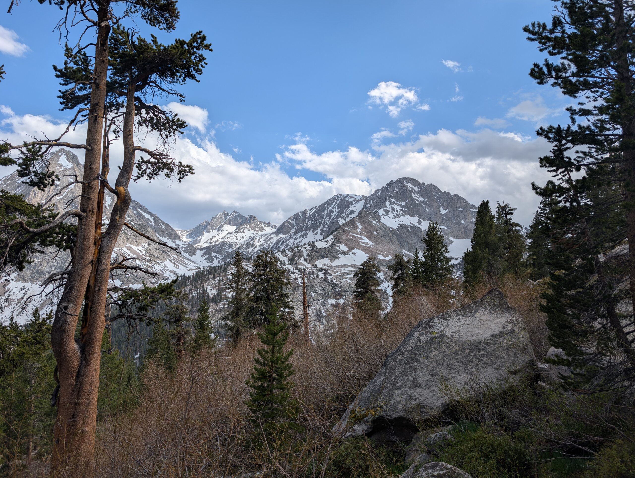
The brief hiatus, new equipment, and epic scenery on the horizon made hiking north from Kennedy Meadows feel like opening Chapter 2 of our PCT thru-hike. It had apparently rained earlier in the day and tread into the sand was a lone pair of footprints. We followed them through the meadow, along the Kern River to our left.

Less than three miles in, we reached Kennedy Meadows Campground. Legend and Bee were camping out, offering spaghetti dinners to all the hikers. We declined the meal only since we had just ate, but were excited to see them again and mingled for half an hour or so.

Afterwards, we walked another two miles but accepted that the day was already winding down and we might just make better progress with a new light. Beyond the Kennedy Meadows Bridge was a lovely selection of campsites along the Kern River. We were the only tent in sight.

6/2 – Day 44
21.4 miles from South Fork Kern River to Gomez Meadow
We are mandating alarm usage as we progress into the Sierra. It is typically best to start as early as possible to better navigate weather patterns, as well as traverse the highest elevations before the sun has time to melt more snow, which leads to inevitable postholing and treacherous river fording. We started at 6:00am today.

The morning weather was perfectly temperate and the scenery through the southern Sierra meadows was beautiful. We climbed a few thousand feet over impressively well-graded trail. A few snowy peaks were visible in the near distance.

We had multiple notable wildlife encounters. We spied our first black bear of the PCT, a chunky fellow who immediately scrambled away up the hill when he heard us chatting. Next, a marmot with light brown, almost blonde fur on some rocks. In Monache Meadow, we took a lunch break next to the South Fork Kern River Bridge and watched dozens of swallows fly over and out. The bridge was clearly a popular nesting location.

A small group of hikers were discussing the afternoon thunderstorm from yesterday with us. The storm had passed before we even started hiking at 5:00pm. Pockets of thunderstorms that popup in the afternoon are a common yet threatening weather pattern in the Sierra. The tricky is part is that if you see a mass of storm clouds, you have no idea which direction they are headed. Whether the storm will miss you or tear you a new one is a toss up.

We walked directly into some slightly ominous skies and decided to bail to our tent after the first sprinkle. I was fairly confident it would pass, but there’s really no harm in taking a break to lay down and read a book in the great outdoors. At some 8,000′, we were still surrounded by pine trees and felt we would be safe in the event of a serious storm.

It rained on and off and we waited for the thunder to relax before tearing down our tent just after 3:00pm. Up ahead was a second climb over an unnamed pass. We worked on it for the next several miles, eventually cracking 10,000′, still under treeline the whole way. The scenery was growing more incredible with every step. Just beyond the pass, we ate a bean dinner, then continued hiking until we descended to a lower elevation to sleep at.
6/3 – Day 45
22.8 (+1.2) miles from Gomez Meadow to Chicken Spring Lake
The skies cleared overnight, leading to a quite pleasant morning that began at 5:00am. After a breakfast break a few miles in, we began climbing another substantial hill past increasingly intense mountains. The apex overlooked Owen’s Valley, a long dried water bed that now looked like a forgotten salt flat. The highlight of the day was witnessing a trio of fighter jets cruise overhead, performing stunt maneuvers.


As we continued ahead, we noticed dark clouds gathering on some adjacent mountains. Another afternoon storm was unleashed, but from our position across the Mulkey Creek Valley, there was blue directly overhead. We hiked as long as we could before hunger pangs signaled for lunch. When we stopped, a sprinkle of rain caught up to us. We setup our tent, ate our food, tore it all down, and continued hiking all in the span of 45 minutes. The plan: continue to outrun the rain cloud.

Amazingly, it actually worked and we stayed mostly dry throughout the afternoon. The entire sky was grey, except a little bubble around Spout and Yeti. The Sierras have a mean look to them when it is storming. We felt like we were heading right into the thick of it, as the trail only continued to take us up higher and higher in elevation.

A blanket of rain eventually landed on us, but did not stick around too long. We breached 11,000′, and started encountering small patches of snow. Spout was struggling to catch her breath at this point, and the progress in the late afternoon was slow and tedious.

At last, we came upon Chicken Spring Lake, the first alpine lake of the PCT and what many consider the beginning of the High Sierra. We decided to call it home for the night. I chickened out of springing into the lake, but filled my bottle and felt inspired to rate every significant alpine lake in the Sierras. My intent is to be as subjective and biased towards my own personal experience as possible.
Chicken Spring Lake – 7.5/10
Swim? No

The water from the outlet was clear and delicious. Surrounded by granite cliffs, the setting was epic and awe-inspiring. It earns a bonus point for being the first true alpine lake heading northbound. However, the weather was dismal and the cold rain made the prospect of swimming unappealing.

6/4 – Day 46
16.1 (+1) miles from Chicken Spring Lake to Crabtree Ranger Station
A reality of life on the trail is the occasional sleepless night. Plagued by anxiety or the effects of high elevation, this was the case for me. At least Spout woke up bright eyed and bushy tailed at the ripe hour of 4:30am. We took down camp and hiked to the southern boundary of Sequoia National Park.

It seemed like it might be a blue bird day. Then, just like clockwork, clouds materialized out of nowhere before noon. We descended to Rock Creek Canyon, which was the first gushing river we had encountered. Fording was not necessary, however, since there happened to be a downed tree across the water nearby. Despite her adept hiking ability, Spout is timid when it comes to any situation with the possibility of falling. Crossing the log took some time, but she eventually made it safely across.

The trail made a steep ascent to Guyot Flat that left both of us hunched over. The climbs throughout the Sierras have not only had a steeper grade than previous sections, the air is thinner so it provides less oxygen. After hiking hundreds of miles, I have become acutely aware of what pace I can comfortably sustain. It was strange to find myself winded after a climb that I could usually handle no sweat.

We started down a hill towards Whitney Creek and were both awestruck as we stood in front of the monstrous protrusion of rock that was Mt. Whitney. It was hard to believe we were there at that moment. Just days ago, we could barely see the high peaks from a distance. Now, we were next to the highest peak in the Sierra Nevada.

We made one final climb to the junction where the PCT joins the John Muir Trail at Whitney Creek and turned off towards the mountain. One mile further was the Crabtree Ranger Station and campground, where nearly all hikers setup base camp before Mt. Whitney.

We pitched our tent away on the other side of the creek, away from some thirty or more tents occupying a field. Just over the hill, Whitney Creek flowed through a grassy meadow that looked like it may have been inspiration for Breath of the Wild. A hiker was playing an ocarina in her tent, and the vibes were immaculate. Then, as 5:00pm rolled around, it grew quiet as everyone was going to sleep in preparation for summit day.

6/5 – Day 47
7.1 (+16) miles from Crabtree Ranger Station to Tyndall Creek
We had agreed to wake up at 2:00am, but a few noisy, passing hikers roused me sometime before 1:00am. I was wired, caffeinated, and ready to go, but let Spout snooze for forty more minutes before shaking her awake, “c’mon, time to go climb Mt. Whitney!”


It is wise to start as early (or late) as possible, essentially to hike when the snow is solid and finish before the risk of thunderstorms in the afternoon. A 2:00am start had us at the back of the train. Others started even before midnight, chasing a Whitney sunrise.

We left our tent set up and stored our extra food in bear cans, reducing our packs to a day’s worth of essentials. Then, we began hiking through the dead of night. The first few miles were gradual uphill, guided by the light of the stars and the feint band of the milky way overhead. Some of the stars were moving: the headlamps of dozens of hikers, miles ahead and thousands of feet above us, working their way up what appeared to be a massive black wall.

After reaching Guitar Lake, the trail grew marginally steeper and we encountered stretches of deep snow. Pathfinding in the dark was as difficult and tedious as the hiking itself. This continued for the next two miles or so, as the light slowly returned to the landscape. We caught our first views of the unbelievable terrain surrounding us. The cliffs were cathedrals of granite.

At length, we reached a series of long, grueling switchbacks that ascended the ridge to Trail Crest. Some of the switchbacks were clear, while others were covered with snow. We equipped our microspikes and ice axes, carefully abiding to the existing boot track. It was best to not think about the consequences of slipping and failing to self-arrest. In total, there were six sections that I would consider at least somewhat sketchy.
Even when the snow was absent, the trail was still steep, rocky, and exhausting to follow due to the high elevation. We finally made it to the junction with the Whitney Portal, which turned north for the final two miles and 1,000′ of climbing to the summit. The sun was now fully risen and it was hard to determine if it was the lack of oxygen or the scenery that was taking my breath away.

The final push was equally difficult, however not nearly as treacherous. A mile of mostly clear trail with a few light rock scrambles led to the largely snow covered, western face of the Mt. Whitney. Groups of hikers were now hiking back down, passing us with congratulatory words of praise.

At 7:20am, Spout and I conquered Mt. Whitney. There was nobody on the summit except for us. Standing at 14,505′, we were likely higher than anyone else in the United States. It was one of the most challenging hikes of our lives, pushing us out of the comfort zone on multiple occasions, but was tremendously rewarding. The 360° view was almost overwhelming. In any direction was a landscape so unimaginably dramatic, I could not determine the best place to look or point a camera.

We did not stay long, since there was incentive to traverse the snow fields before they turned to mush in a couple of hours. In total, the down climb took about an hour less than the journey up. The neat part was being able to see the lakes and streams we had passed earlier in the dark. However, Spout and I were both cooked as we hobbled back to camp. The only thing on my mind was reaching the tent and collapsing onto my pad.

We made it back at 12:20pm and I took the fattest nap in history. As much as we both would have preferred to relax at our campsite for the remainder of the day, we had a connundrum. It was in our best interest to hike to the base of Forester Pass, so that we could clear the stream crossings and traverse the snow in the morning. Reluctantly, we tore down our tent and continued hiking.

Back on the PCT, we fell into stride with Mock, who had the same plan as us. We committed to hiking 7 more miles, fording two knee-deep streams before crossing the Bighorn Plateau. It was a lovely evening, and the first day since we entered the Sierra that we did not have any rain. We approached Tyndall Creek and finally made camp at a serene pond just beneath Tawny Point. It was after 7:00pm and we were both ready to drop.


6/6 – Day 48
14.8 (+1) miles from Tyndall Creek to Kearsarge Pass
I slept like a log. We started the day early again, this time at 4:30am so we had time to negotiate the morning obstacles that we anticipated coming. Not a half mile downhill from our campsite, we had to start the day by walking through the knee-deep, Tyndall Creek, which was as cold as the snow melt flowing through it.

With our polar plunge out of the way, it was time to face what was both the first of the major mountain passes and the highest point on the entire PCT: Forester Pass. We emerged from the trees onto a massive snow field before the grandest of mountains.

For the first four miles, we hiked with our microspikes across an icy crust, occasionally losing the trail on a false boot path. We teamed up with Strings, who wisely did not want to attempt the approach alone, then made the final push.

The trail followed a series of steep switchbacks for the final 1,000′ of the climb. Roughly half was still covered in snow. Nearly at the top, we crossed a chute that was still entirely frozen with a steep drop-off to the left, but it felt safe as long as we did not deviate from the existing boot track. At 13,120′, we reached the top of Forester Pass and were rewarded with a jaw-dropping view of Kings Canyon.

The north side of the pass had significantly more snow. There were two obvious ways to get down: walk a mile of switchbacks through slushy snow, or do not walk at all. We chose the latter. Our glissading technique could use some work, but it did the trick. We slid on our butts down the snow 800′ to a frozen lake. Spout lost control at the bottom and nearly took me out.
It was now 10:00am and the sun had been heating the snow for a few hours. However, it was still firm enough to avoid postholing. We spent the next few hours trudging on top of the snow, descending into an epic valley between mountains larger than life.

When we eventually hiked to a low enough elevation, we took a long break among the trees. Spout laid out her shoes and socks in the sun to dry. Immediately afterwards, we came upon an unnamed tributary of Bubb’s Creek that required us to ford once again, re-soaking her lower body.

After finally bottoming out, we began a final climb towards Kearsarge Pass. A mile up, we turned off the PCT to follow the Kearsarge Pass Trail, which was our exit portal to the nearest town. This stretch of the Sierra was so isolated that we needed to hike an additional 8 mile one-way trail over a mountain pass just to reach a road. This was true wilderness.

We did not plan on making it over Kearsarge Pass and stopped two miles short at a stunning overlook of a Bullfrog Lake. This was perhaps the most beautiful spot I have ever pitched a tent. Spout and I sat on a granite shelf and watched the clouds shift and swell between the peaks.

6/7 – Day 49
0 (+6.5) miles from Kearsarge Pass to Bishop, CA (Eastside Guesthouse)
Sleeping in until 7:00am was a blessing. Both of us felt the strain from the past couple of days and were excited to reach town. We camped less than two miles from Kearsarge Pass, and the hike to the top was fairly forgiving.


From the pass, there was about 4 miles downhill to the Kearsarge Pass Trailhead and parking lot. There was a minimal snow and we finally returned to our regular 3mph hiking pace to reach the bottom just before 10:00am. Bison, The Best Around, and Nude Beach were already waiting at the bottom for a hitch, however since it was a sunny Saturday morning, all the day hikers were heading into the mountains, not out.

Thirty minutes or so passed before Spout just asked a woman if she could shove 7 hikers in her truck. Somehow, she was okay with it. She drove us down the mountains into the town of Independence, CA, where we waited for a second hitch. A man picked us up in a Cybertruck and took us all the way into Bishop, CA. This was one of my most anticipated visits on trail, famous as one of the best hiking and climbing towns in the country.

We ate lunch at Erick Schat’s German Bakery, which was a unique experience. Afterwards, we checked into Eastside Guesthouse for the night and performed our usual town chores. A group of hikers that evening coordinated a bowling party at Back Alley. We occupied two lanes with silly names like Bison, The Best Around, Nude Beach, Jukebox, Mock, Uncle, Polaroid, Critter. I bowled what was probably my best game ever, turkeying once to score 141, sweeping the competition. Needless to say, thru-hikers should stick to hiking.

The party continued at the Hostel California with an impromptu jam session in one of the detached shacks. The crew we found ourselves with were all seriously talented guitarists and singers. “Fly Away”, “Clay Pigeons”, and “Take Me Home, Country Roads” were a few of the greatest hits. It was a magical evening in one of the coolest mountain towns around.
What’s Next?
We continue working through Kings Canyon National Park and enter the heart of the Sierras. Every day of hiking will involve climbing up and over a mountain pass. We have a long stretch of wilderness before we reach the next town of Mammoth Lake, CA.
How’s It Going?
The Sierra has brought upon new challenges that have forced both Spout and me out of our comfort zones. The first few days in the high altitude were humbling, but incredibly rewarding. Spout seems to be affected more by altitude sickness than me, but we are both lucky that we did not experience any serious symptoms beyond subtle headaches.

Food & Resupply
For this resupply, we both packed 6 days of food in bear cans, as required by Sequoia and Kings Canyon National Parks. This was a pretty difficult task. Prioritizing the caloric density of the food we bought was key.

I tripled the amount of cashews I normally pack. Peanut butter, Pro bars, Complete cookies, couscous, and peanut M&M’s (these have a ridiculous number of calories per gram) were staples. I topped off the bottle of olive oil to pour into every meal. Dinner was a full pot of refried beans, which were downgraded without crumbled up Fritos to sprinkle on top.

We packed out Subway sandwiches for the first night out of KMS. This effectively gave us an extra day of food to play around with. There was always the chance that bad weather would delay our plan to summit Mt. Whitney and we would need to wait another day. When we made it to Bishop, we each had about a day of food leftover.

Gear Changes
We made numerous changes to our equipment to be prepared for the conditions in the Sierra, which is a totally different environment than the desert.
- We both added a BV500 bear can to secure our food overnight in accordance to NPS regulation
- We both replaced our first pair of shoes with fresh Altra Lone Peak 9s (Yeti’s is the Vibram 9+ model). 700 miles is perhaps too long to run a single pair, the insoles were flattened at least two hundred miles ago and the tread was deteriorating on the toe of both of the shoes
- We both added a pair of Kahtoola MICROspikes for increased traction when walking over snow
- I added a CAMP Corsa 70cm ice axe and Spout added a Pretzel 60cm ice axe. These provide additional safety for hiking across icy terrain with a steep, snowy slope to one side. They also are handy for glissading. We are not using them to scale walls like Marc-André Leclerc
- I swapped my shorts for a pair of long pants, Patagonia Terrebone Joggers, and Spout swapped her shorts for the REI Sahara. We wanted long pants to help with bug protection, protect our legs from UV, and save our asses when glissading
- I added a pair of ExOfficio underwear
- Spout removed a pair of socks, now carrying only 2
- I swapped my Frog Toggs poncho for a Frog Toggs rain jacket. I think the jacket will perform better in cold rain and high wind
- I added a pair of MLD Event rain mitts. My hands are always the first part of my body to get cold, especially in rain
- I added a Lixada solar panel that plugs into a battery to charge using the sun. The plan was to hang it off the back of my pack and also lay it in the sun over breaks
- We both removed a 1L smartwater bottle, anticipating there will be much more water
- We both added Sea to Summit bug nets, in case we encounter more mosquitoes
- I treated all of our clothes with Permethrin bug repellant

Notes
- The mileage for each day gets confusing when we take so many side trails. I am going to continue listing the “PCT miles” that we hiked each day according to FarOut. Any additional mileage, like the Mt. Whitney side trail, will be listed in parentheses
- REI sent us the wrong size for Spout’s ice axe and we were unable to find the model she wanted at the store. There was a gear outfitter at Kennedy Meadows and the lightest axe they had in her size was the Petzel
Just read all of this and it left me breathless!💓💓 Continues prayers for more safe miles. The photography and journaling are terrific. Love you both!🙏🙏🙏🙂💗💗