
5/22 – Day 33
24.5 miles from Tehachapi Willow Springs Rd to Golden Oaks Spring
Feeling refreshed from the day off, we packed up and checked out of the hotel. We grabbed drinks from the local coffee shop and sat to enjoy them. We had a schedule to keep if we wanted to reach Kennedy Meadows South by May 28 (when we had arranged to be picked up) before taking a few days off trail. Once we finished our drinks, we hitched back to the trail by 9:00am, thanks to a nice man named Paul.


There were 8 miles of trail between the two roads leading to Tehachapi, CA. We had taken the first and spent the morning cutting through a massive wind farm to reach Highway 58. This was quite possibly the windiest section yet, gusts surely reaching 50mph or more. The highway was significant in that it meant switching to the next FarOut map: the Sierra. The Tehachapi Crest was the geological beginning of the Sierra Nevada range, even though for now, it looked similar to the rest of the desert.

There was a water cache just beyond the overpass, which came in clutch since it was otherwise a 25 mile dry stretch from where we began. With over 6 days of food and 3.5 liters of water, this was the heaviest my pack had ever been, and my shoulders were well aware of the fact. After filling up, we locked in to tackle a five mile climb up the next windmill-infested mountain.

We took a short, shaded siesta near the top. It was a pretty uneventful day, but we kept moving in hopes to camp near or at the next water source. Pixie and Pilgrim caught up with us eventually and we followed them to Golden Oaks Spring. After filling a bottle each, Spout and I searched for a campsite.

Hangry and exhausted after the long day, we had a disagreement over where to plop down our tent. Wind protection and levelness are the most important factors, but finding a site that offers both is difficult, especially when competing with dozens of other hikers in the midst of “the bubble” we found ourselves in. Ultimately, we ended up hiking backwards a quarter mile to a slightly sloped spot between two bushes.

For dinner, we split a freeze-dried Mountain House meal of chicken fried rice (it tasted like dog food compared to our beans). In total, the meal was 600 calories, which meant we were each consuming a whopping 300 calories to refuel after a 25 mile day of hiking up and down mountains. This was not our strongest resupply and we were not confident we packed enough food.

5/23 – Day 34
21.9 miles from Golden Oaks Spring to Dispersed Campsite
We slept in past 7:00am and I felt lethargic throughout the day. Despite the trail hardly daring to climb more than a few hundred feet at any point, the going was tough. When rock climbing, we might say it is a “high gravity day” when it feels harder to get off the ground and that seems relevant to backpacking too.

Just after leaving camp, we stopped again at the spring. The water trickled slowly from the pipe, taking over a minute to dispense one liter. For the first time ever, I had to wait in line behind several hikers for a chance to fill up a bottle with water.

Beyond the spring, the tired scene of windmills dotting the hills continued. We lumbered along, stopping for a break only when one of us had a good reason. The mileage we travel between rests has been increasing. Now, we often find ourselves walking six, seven, eight miles without sitting down, unless one of us needs to poop.

After lunch, we came upon a distant view of a mountain with a bright red line smeared across, maybe 100′ wide and long enough that it continued wrapping around the hills. We are fairly sure that it was flame retardant used to contain a recent wildfire that burned only a few days prior. The Jaw Fire started 2 miles off the PCT and there were concerns that it would spread. Fortunately, the fire crews managed to contain it impressively fast.

Pine trees returned to the trail after a few more miles. It may not seem like much, but the coniferous aura contributes so much to the quality of a hike: shade, padded trail, and rich aroma. Afterwards, there was another brief stretch of horrendous blowdowns, but we otherwise cruised all the way to Robin Bird Spring. Here, we walked up to a tramily of five who were all standing side by side brushing their teeth. I’ve never seen this many people brushing in unison before. Their dentists would be proud.

The same tramily had occupied all of the flat sites near the spring, so we continued hiking another two miles until we reached an isolated hillside with plenty of space. We have noticed that most other hikers only bother tenting at specific sites marked on FarOut. You can pitch a tent pretty much anywhere on the PCT and we always have better luck just hiking on a few miles to find the hidden gems.
5/24 – Day 35
20.6 miles from Dispersed Campsite to Blumpkin’s Crossing
We slept in again, slowly noticing that our bodies are demanding more and more recovery time. At 8:30am, we started our daily walk north. Our plan was to travel 5 miles to an established campground called Lander’s Camp, where we could fill up water and use the pit toilets. Long story short, we ended up splitting up and Spout walked an extra two miles to reach the camp.


My goal today was to reach 100% hydration. This was difficult to achieve since the upcoming stretch did not have another water source for 35 miles, likely the longest of the entire PCT. This would have been a serious ordeal that would have required us carry at least 7 liters of water just to remain moderately hydrated. Fortunately, there were two separate water caches in between, so we made do with just a few liters. We stumbled upon the first of these caches seven miles later.

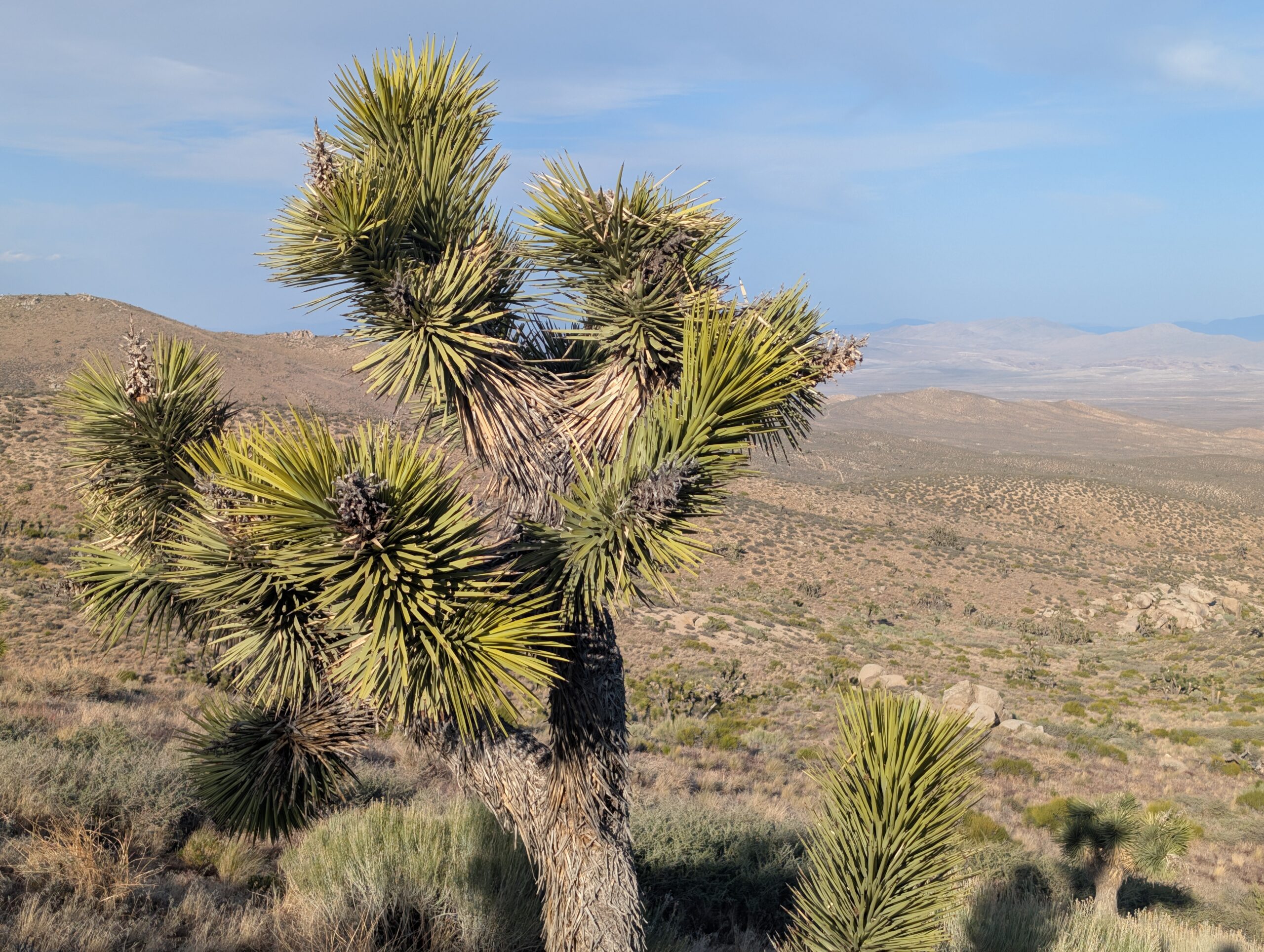
Though we would have preferred to continue hiking among the conifers, the trail took us right back into the desert. Joshua trees were abundant here, as was the old, familiar paddle cactus. I have a soft spot in my heart for joshua trees, and stopped complaining about being in the desert as soon as they made their grand reappearance.

We made the last of the minor climbs of the day and came upon a nice, sandy campsite with scattered yuccas. The sky was painted red at sunset and the world around us settled into bliss. This was the desert I always dreamed about on the PCT.


5/25 – Day 36
27 miles from Blumpkin’s Crossing to Walker Pass Campground
Setting an alarm was the difference between hitting the ground running and sleeping in until the sun turned our tent into an oven. Starting off at 6:00am, we strategized early to break our day into three, 6.5 mile chunks with breaks in between: one to a water cache, the next over a mountain, and the last to a spring.

The first leg was easy enough, but the trail introduced loose, beach-like sand that was quite frustrating to hike through. We dealt with this as we made our way down to Bird Spring Pass. We sat in the shade of some more joshua trees, gulping down as much water as we could stomach. Then, before the sun had enough time to unleash its fury, we began a three mile climb towards Skinner Peak.

As usual, the uphill trail was gently graded and we topped out before too much longer. As we wrapped around the side of mountain, BAM, a new biome rendered in the distance with snow-capped peaks featuring the polished gleam of granite. There was no mistaking it; the high Sierra was finally within sight.

Excitement brewed as we descended through the Kaviah Wilderness. However, the desert was not quite ready to exit stage south and we bounced around dusty hills for the next several miles. Eventually, we followed a dirt road for two more miles, as dirt bikes and dune buggies cruised past. It seemed everyone was out enjoying their Memorial Day weekend.

Considering the holiday, Spout and I had a strong feeling, or perhaps a manifestation, that there would trail magic at Walker Pass Campground. Highway 178 was the last major road before hundreds of miles of remote wilderness and the campground was a popular spot for RV campers. We made the tremendously irresponsible decision to skip a quarter mile side trail to a spring, so that we could save our legs and push ahead 7.5 miles to the camp. We each only had half a liter of water, but an extra half mile of hiking was out of the question. Textbook hiker math.

The rest of the hike was mostly downhill and quite beautiful. Silver lupine and the yellow buds of Frémont’s mahonia were in bloom. Every time my watch buzzed to let me know I walked another mile, I took a sip of water.

Half past 5:00pm, we made it to Walker Pass and, lo and behold, there was trail magic. Goldie was the only familiar face, but we aquatinted ourselves with another new group of hikers. A fellow named Pennsylvania brought all of the essentials: fresh fruit, chips, Gatorade, Caprisun, and Uncrustables. Apparently, when Pennsylvania asked a previous hiker what to bring for trail magic, they responded, “pack a cooler like you’re providing lunch for a peewee soccer team”.

Our ragtag soccer team hung out under a pavilion for the rest of the evening. As it grew later, hikers started dropping out one by one and we found an open campsite behind a knotted joshua tree. We thanked Pennsylvania for his generosity, then he left us with two crocheted jellyfish that his wife made.
5/26 – Day 37
22.8 miles from Walker Pass Campground to Dispersed Campsite
We left Walker Pass around 9:00am, heading northbound to the Owen’s Peak Wilderness. This started as a climb towards Morris Peak that ate up most of the morning and burned off all of the Uncrustables we ate for dinner last night. Near the top, we were treated to the sight of a jagged granite slab on an adjacent ridge.


The upcoming spring reportedly contained trace amounts of uranium. Though other hikers did not seem to care, we skipped it. The sun was providing more than enough radiation as it was, no supplement needed. As the day went on though, the sky became overcast and the temperature held to around 65°. We made a lengthy descent around Owen’s Peak into a beautiful valley.

The next water source was Spanish Needle Creek, the first flowing stream we have crossed in at least a hundred miles. However, where there is water, there are bugs. As mosquito season kicks off, this was a stark reminder of what to expect further north. Spout’s foot soak was cut short as we had to quickly hike away from the swarm of pesky bloodsuckers.

By 6:00pm, we were ready to hang up our boots for the day, but figured we would keep moseying along awhile later. This turned into a 2,000′ ascent up the next mountain, searching desperately for spot to throw down our tent along the way. At a certain point, we convinced ourselves that it was good to get the climb out of the way and we would just head to a marked campsite at the top. Of course, seven tents were already crammed into a site meant for three, so we were forced to continue on past sunset.

Fortunately, we found a prime tent spot just a mile further. It was on a windy ridge overlooking the town of Pearsonville, CA, nestled in some trees for complete protection. We listened to the wind rip through the pines all night long, but our tarp was barely affected.


5/27 – Day 38
22.8 miles from Dispersed Campsite to Kennedy Meadows
Today was our last full day of hiking in the desert, or southern California, or whatever you want to call this section of monotonous, sandy hills highlighting only the humble shrub brush. The mountains were beginning to change, ever so slightly. Beyond their geological composition, they also just seemed to have a bit more umph to them.

During our descent towards Chimney Creek, we hiked past the jagged crown of Lamont Peak. Then, we tackled the only climb of the day, up an exposed hill that skirted Chimney Peak. From here, we caught an epic view of the most southern peaks in the high Sierra, including Mt. Kaweah, Mt. Kern, and the foreboding Mt. Whitney.

Beneath us was a sweeping valley sparsely covered by limber pine. It was not the Kennedy Meadows, but it was close, and practically adjacent to our destination which was less than ten miles away.

The trail was nearly flat for the final few miles before Kern River, where we stopped for the night. Next to our site was a large, flat rock that I laid out on until dusk. I listened to an audiobook of Robin Wall Kimmerer’s “Braiding Sweetgrass”, which seeks to mend our society’s broken relationship with nature by linking traditional and scientific knowledge. It is a beautiful read.
5/28 – Day 39
5.3 miles from Dispersed Campsite to Kennedy Meadows South
The choice was to wake up for breakfast or sleep in for lunch. Spout and I are breakfast people and Grumpy Bear’s is known for pancakes, so the choice was simple. By 6:15am, we were hiking through the valley. We followed the Kern River for a short stretch, popped through a few piped gates, and officially entered Kennedy Meadows.


It was five quick miles before the trail intersected Sherman Pass Rd, the last paved road for roughly 240 miles northbound. A mile east was the Kennedy Meadows General Store, three miles further was a restaurant called Grumpy Bear’s Retreat. A man was dropping his wife off at the trailhead to begin a sans desert thru-hike of the PCT, so Spout and I just stood chatting with them until the man eventually offered to drive us.

Stepping onto the porch of Grumpy’s was an overwhelming surprise. “Introvert hell”, as one FarOut comment nicely described it. At least 50 hikers were crammed onto the porch, waiting for the doors to open. Nearly all of them were new faces, yet at the same time they all looked similar: shorts, sun hoodie, ball cap, beard. We recognized Pixie, Pilgrim, Goldie, Raccoon, and Pipebomb and joined them for breakfast. This was likely to be the last time we saw them on trail, as most hikers were heading directly into the Sierra, while we were taking a few days off. It felt sad, but this is how long hikes tend to go, and there are always new folks to meet.

There is an unwritten challenge to eat two whole pancakes at Grumpy’s. Sounds easy right? I was proud to be the only hiker there who managed to finish one (Spout was surprisingly close), but two would have probably killed me. Around noon, our sisters, Lucy and Jillian, pulled up in a rescue mission. Having showered in the past week, they looked out of place with the rest of the hiker trash, but we were excited to see them regardless. They stayed for some nachos before loading us up into the car and driving down the winding road towards Ridgecrest, CA.

It was possibly hotter than any day we experienced on trail. This was fantastic news for the snowmelt in the Sierra, which was part of the reason we were taking time off. The four of us nabbed a hotel in town and spent the remainder of the day alternating between lounging in bed, eating Mediterranean food, and hanging out by the pool.
5/29-5/31 – Days 40, 41, & 42
0 miles in Las Vegas
The original plan was to drive to Las Vegas, then fly round trip to Pittsburgh to spend a day with our new baby nephew, JJ. Unfortunately, little JJ was sick and we had to cancel our flight. Instead, we spent three days at Hali’s house in Las Vegas.

Taking time off before entering the Sierra allowed additional time for snow to melt in the mountains. It also gave us plenty of time to prepare, do laundry, shower, clean the sleeping pad, swap out gear, resupply at a Walmart, and figure out how we were going to fit a week’s worth of food in a bear can without Hali’s ridiculously good packing skills.
The greatest boon was spending time with family. Having three full days to basically just lounge around and do nothing was a complete mental reset. My body appreciated the additional recovery time. Any lingering pain I had disappeared. The food we ate was fresh for multiple consecutive meals. It felt like we were biding our time, boosting our power level for the next ground assault.

It was also an exercise in slowing down. I tend to struggle with pace apprehension on trail, always feeling like I need to be somewhere, like there is never time to stop. When someone passes during a break, I feel like I need to start hiking again. Surveyed thru-hikers overwhelmingly report that they wish they had slowed down during their hike. There is no rush.
What’s Next?
We enter the Sierra via Sequoia National Park. The next few hundred miles traverse the John Muir Corridor, famous for being one of the premier hiking locations of the world. It contains some of the tallest mountains in the country. Nearly all of it is only accessible by foot and we will not be able to communicate much at all. There are new challenges related to high alpine hiking in the early summer, such as climbing mountain passes over 12,000′ in elevation, treading over snowpack, and fording strong currents. This is what we have been looking forward to since Day 1!
How’s It Going?
The past week has been a bit rough for me. I am no stranger to adversity, but that does not make it any easier to overcome. When setting out to do the AT, I had never attempted anything like it before. Was I even capable of hiking 2,000 miles? That was the challenge. On the PCT, I know I am capable of doing it. So… what?
Thru-hiking is not difficult because of “that one climb” or “that one snowstorm”. It’s difficult because the challenges present themselves day after day for multiple months. The only way to overcome them is through drive, having a purpose for doing so. I suppose Spout and I are still learning about our motivation. If you were to ask me why I am thru-hiking the PCT, I would probably say it is for fun. However, for the times when it is not fun, maybe something else is needed.
The good news is that we both are feeling healthy and strong. Random pains still pop up occasionally, but they are becoming less frequent and typically disappear quickly. We completed 703 miles through the desert in fewer than 39 days, without feeling like we were “pushing it”. I logged over 1,000,000 steps in May. My highest day was over 67,000 steps (~32 miles) on 5/19.
Food & Resupply
We hiked 144 miles from Tehachapi to Kennedy Meadows on a single resupply. My food bag was a mess, containing about half the contents of a resupply box we sent to Hikertown and half new food from Walmart. I made it without going hungry, but had only two oat bars and a single bag of beans and rice remaining when we reached town. However, I feel we have it dialed in moving forward.
For the next few weeks, all of our food will need to be packed within two bear cans, BV500s, for long, remote stretches. This means we need to prioritize calorically dense food and generally take our resupplies a bit more seriously.
Notes
2025 Sierra Snowpack Notes
- We are monitoring postholer.com to gauge the amount of snow in the Sierra before entering
- 2025 has been an average year for total snowfall
- Melting has accelerated in the past two weeks, due to higher than usual temperatures
- Many hikers are entering in late May, some without MICROspikes or ice axes, however we are playing it safe by waiting until June 1 to allow more time for the snow to melt and are bringing the aforementioned equipment
Following with excitement for you both. I really love all of the excellent journaling.
Prayers for a great hike through those mountains. Love you! 😘 You two are amazing!!
Hike Faster! Come Home!!!! I miss you guys!!!!