

6/8 – Day 50
0 (+6.5) miles from Bishop, CA to Kearsarge Pass Trail junction
We executed our signature double nero strategy perfectly. After a short hike over Kearsarge Pass to arrive at Bishop yesterday afternoon, we planned to soak up as much town energy as possible before hiking out. We sipped Black Sheep Coffee and ate breakfast at Great Basin Bakery. Both were A+. Then, we walked to Von’s to resupply for another 6 day stretch.

Hitching back to the trail was surprisingly difficult. Bishop Family Fun Day was happening at the local park, so maybe the parents were scared of stinky hitchhikers. Eventually, a young woman from the Big Pine Paiute tribe scooped us up. She went out of her way to drop us off at Independence, CA. From here, a former PCT hiker drove us back to the Kearsarge Trailhead. He explained the fascinating history of how Los Angeles swindled the water supply of Owen’s Valley.

When he dropped us off, it was about 5:00pm. We hiked back up towards Kearsarge Pass, which was a pleasant hike with several small waterfalls and streams. It had only been one day since we hiked down, so not much had changed. However, we did notice that a patch of snow next to our previous campsite had melted entirely. Back in Owen’s Valley, it was 100°.

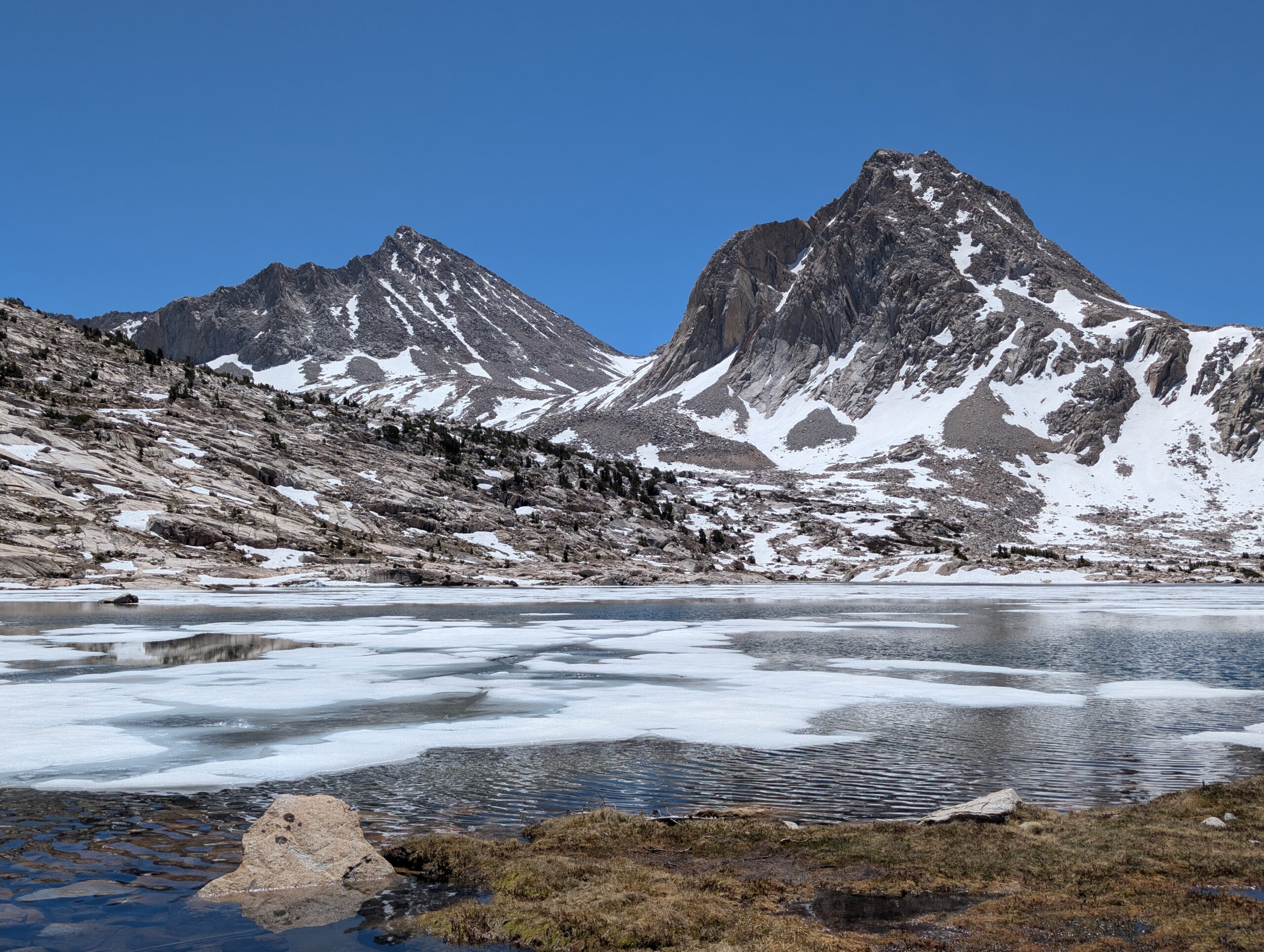
We managed the pass with relative ease and hiked until we were within spitting distance of the junction to the PCT. It was a strategic position that would allow us to tackle Glen Pass early tomorrow. Dinner was Italian subs that we packed out so we could have a final fresh meal before a week of dried food.

6/9 – Day 51
15.6 miles from Kearsarge Pass Junction to Pinchot Pass
We were unsure of what to expect from Glen Pass as we made our morning approach around 6:30am. Receiving updated information on trail conditions is basically impossible since hikers do not have cell service to leave comments on FarOut. On trail, there were the usual patches of snow, but we did not even bother pulling out our axes. The climb was fairly steep, but not especially difficult and was capped at 11,957′.


The other side of pass coming down, however, was like walking in a winter wonderland. Despite the morning sun beaming the north face of the Glacier Spike, the snow was still several feet thick and persistently stubborn. A deep boot track was carved out roughly where the trail might have been. The only reason this was any different from the other times we crossed snow was that the boot track heading down had a dangerously steep grade and was entirely exposed.

After a tough mile tip-toeing along the ice, the boot track vanished onto a rock slide. Essentially, hikers will always find the past of least resistance when the trail in inaccessible. Scrambling down a river of rocks was apparently an easier route a few weeks ago than carving out more boot track, and now that was the closest thing to a trail we could follow. It was harsh on the knees dropping from each rock, but no worse than the snow.

Near the bottom of the rock scramble, we had the opportunity to glissade a small hill or two. Then, we continued crunching our way through the snow until we reached Rae Lakes. This was a worthy prize for conquering Glen Pass. For the next few miles, we traversed flat trail between the gorgeous alpine lakes.
Rae Lakes – 9/10
Swim? Yes

There are three cascading lakes, Upper, Middle, and Lower Rae Lake. The PCT even fords the outlet between the Upper and Middle. All three were equally beautiful, featuring epic backdrops or small islands floating in the center. Spout and I both made the plunge into the shimmering waters of Upper Rae Lake. Just an all around amazing place, no complaints. Minus one point because they are too mainstream.

The descent took us down and down for many miles, even dropping below 9,000′ in elevation. Along the way, we passed Arrowhead Lake and then Dollar Lake further down. The sun was beating, and afternoon clouds did not even bother to roll in today.
Arrowhead Lake – 6.5/10
Swim? No

This lake has a prime location along the descent of Glen Pass, but I cannot help but feel it is overshadowed by Rae Lakes. It is certainly beautiful, but it was too ambitious in its placement.
Dollar Lake – 7/10
Swim? Yes

This was an understated lake that did not try to be anything it was not. Spout and I waded in across the sand to find the water warmer than the previous lakes. It was an all around pleasant swimming experience.

At the bottom of the descent was a suspension bridge built across Woods Creek. Good thing too, as the current was much too powerful to cross otherwise. We followed the creek up and out of the valley, the Woods Creek Waterslide to our right. Daring to actually give the waterslide a whirl would have probably flung us all the way back to Kennedy Meadows.

I stopped counting the number of streams we forded after 5. Most involved wading through water just above the knee. We do not even bother removing our shoes and so our feet are consistently wet. We hiked as far as we could up the pass until snow was covering the surface and selected a decent flat site before Pinchot Pass.

6/10 – Day 52
14.9 miles from Pinchot Pass to Posthole City Palisade Lakes
On deck was a double pass day over Pinchot and Mather, which are fewer than 10 miles apart. Our alarm rang at 5:00am and we snoozed for another hour before attempting the first. It was another relatively hot day for the mountains, which meant the snow was melting fast.

On the approach, we traversed a full mile of snow among frozen lakes and rushing streams. The climb to the pass itself was quite forgiving with the majority of the switchbacks entirely clear of snow, save for a few rough patches.

We descended Pinchot Pass with Carebear and Hottub. Like the way up, it was a mixed bag of snowy boot track and a few rock scrambles. By the time we had made it down to Lake Marjorie, it was starting to get warm and we decided a swim was the best way to celebrate completing the pass. The lake was still 50% frozen. As soon as the shock wore off, it felt amazing to lay out in the sun to dry off. This lake was technically not one of the alpine lakes marked on FarOut with a duck icon, however, since we had missed swimming in two of those, this was consolation.

In between the two passes was about four miles of descent and a handful of stream crossings, followed by five miles of climbing towards Mather Pass. At the lowest point was the south fork of the Kings River, the deepest crossing we had yet faced. Water was gushing to our upper thighs and the footing was tricky on large underwater rocks.

We took lunch after the crossing, then started up Mather Pass with Carebear and Hottub. We played a geography game to kill time, until the terrain suddenly started demanding our full attentions. The final two miles of the approach were blanketed in snow, with occasional islands of rocks. Our progress slowed significantly and it wasn’t until nearly 4:00pm when we made the final push to the pass.

The climb started off alright. Over half of the mountain was snow free at this point. Leading to the top, the trail vanished into a large, lingering snow chute with a long switchback of boot track. Since it was later in the day, the snow was watery and we really did not like the steep snow track leading to the pass. With no other option though, we equipped our axes and Carebear took the lead.

Stepping on the slush would either smear it to the side or result in a posthole of varying severity. At one point, Carebear postholed through a snow bridge all the way to his chest, then said calmly, “my foot is still not touching the ground”. A boot-sized portal to the underworld had been unearthed. He managed to escape unscathed and we all took turns shuffling around it. This little maneuver was probably the most dangerous three steps of our entire hike.

We reached solid ground after a few more yards, but the trail kept leading directly back into the snow. We were forced to scramble directly up the scree, which was sloppy and difficult, but marginally safer. At length, we reached the top of Mather Pass and shared a deep sigh of relief.

On the other side of the pass was a snowy metropolis we called Posthole City. Compared to the ascent, the grade was not nearly as steep, but the quantity of snow was significantly greater. It was a rather tedious slog for well over a mile. We pulled off a few short glissades, but were mostly slipping and sliding until we made it out to a lovely campsite overlooking Palisade Lakes.

6/11 – Day 53
17.1 miles from Palisade Lakes to Helen Lake
We woke up to a curious marmot snooping around our tent. The whole campsite was overrun with the adorable rodents and I was all for it. My dream is to live in the mountains and make a living as a marmot wrangler. For now though, I was still a lowly thru-hiker so I slipped on my soaking wet shoes and started the day.


We first stopped at the Lower Palisade Lake for a morning dip with Carebear and Hottub. Then, we turned west through Kings Canyon through some of the most incredible scenery I’ve laid eyes on. I have grown increasingly frustrated with both my camera and my writing, neither of which seem capable of capturing even a sliver of the magic in the Sierra.
Palisades Lakes – 8/10
Swim? Yes

A beautiful but barren alpine setting makes this one of the most scenic bodies of water yet. The lake is fed by a number of streams and waterfalls, that were cascading to our rear as we dove in. The water was cool and refreshing.

Spout and I hiked downhill for roughly eight miles overlooking the valley, eventually dropping below 9,000′ in a dense woodland. We passed a small aspen grove near the middle fork of the Kings River. Once at the bottom we began climbing uphill yet again, this time towards Muir Pass, still eleven miles away.

We stopped at the flooded, Grouse Meadow for lunch with our friends. Hottub went for a swim, which was weird because it was a meadow (that is how much snow melt there is). Meanwhile the rest of us ate our food and chatted until a ranger came by to check that we were in line. She gave us a bit of info on the upcoming trail conditions.

At 2:00pm, we continued our climb. There were several river crossings and even a few sections where the excessive snow melt had borrowed the trail itself, turning it into an ankle-deep stream.

We admired an unnamed meadow that was so pretty it stopped us in our tracks. Then, after a few more hard fought miles, we reached the start of a snow field that was quite a bit more covered than expected. We selected the last possible campsite before the Arctic tundra began, saving the ordeal for the morning.


6/12 – Day 54
19.2 miles from Helen Lake to San Jauqin River
I left my socks, gaiters, and shoes outside overnight to dry, as usual, and woke up to all of it frozen solid. It was one of the coldest mornings yet. This was helpful for the remainder of our ascent to Muir Pass, since the snow was much easier to traverse with spikes. However, it was not so great for when we reached Helen Lake, the next “duck” lake.
Between Spout, Carebear, Hottub, and myself, nobody would have jumped in the lake alone, but a group mentality fueled by FOMO meant we were all getting wet. We hacked away the ice, then took turns making the coldest plunge of our lives into Helen Lake at the ripe hour of 7:00am.
Helen Lake – 4/10
Swim? Yes

This lake was simply way too cold to be enjoyable. Access was difficult through the ice and the floor was covered in large, pointy rocks that cut up my feet while wading in. The scenery was nice, but not enough to compensate for the poor swimming conditions.

Muir Pass was the least sketchy one we had climbed yet. There were no risks besides a few precarious snow bridges over the streams. It took us a little over an hour to complete the two miles to the top. Here, we found the Muir Shelter, which had a book for thru-hikers to make their confessions. TL;DR: many hikers pooped themselves climbing Mt. Whitney and they are falling in love with their hiking partners.

The north face of Muir was perhaps the snowiest section of trail yet. For three straight miles, we crunched our way down past Wanda and Sapphire Lake. I stopped to bag the latter of these lakes, my second cold plunge of the day and another consolation swim.

We eventually descended low enough that snow ceased and our pace quickened. Another ranger stopped us to check our permits. Then, we took a lunch break at the gorgeous, Evolution Lake, with Carebear and Hottub.
Evolution Lake – 10/10
Swim? Yes

This lake was the full package of beautiful scenery, great weather, easy access, and about as warm of water as you could expect in an alpine lake. There was a nice, sandy entry into the water. The view of the surrounding mountains was incredible. Best swim of the trail so far.

The rest of the mileage on deck was downhill and we finally found ourselves hiking consistently at 3mph pace for the first time since before Mt. Whitney. We chased Evolution Creek through the trees, until we were eventually forced to cross it. This creek was notorious for being difficult to ford, allegedly rising up to chest height during heavy snow years. Fortunately for us, we were past peak snow melt, and the river was no deeper than my waist at any point. Still, it was a wild crossing and the last rapid nearly swept me off my feet.

The final few miles of the day brought us to a picturesque view of the San Jauqin River valley. We were hiking during golden hour when I felt an overwhelming sense of gratitude. Not a day goes by when I do not think about all of the people whom I love and who love me back. I feel truly blessed to be out here.

We made camp on the bank of the roaring river. It was a beautiful site with space for us and our friends. I quickly lit a fire for us to enjoy while eating our dinners and we stayed out a bit later than usual, shooting the shit. Another day in dirt bag paradise.
6/13 – Day 55
18.8 miles from San Jauqin River to Bear Ridge Trail Junction
Leaving camp in the morning, we made one final crossing of the river over a sturdy foot bridge. We officially exited Kings Canyon National Park and entered the John Muir Wilderness. Kings Canyon leaped to the front of my list of favorite national parks after the incredible week we spent hiking through its rugged and remote wilderness.


A bit further up trail, we had another black bear encounter. It was light brown in color and was one of the largest we have seen in the wild. As usual, it was more scared of us than we were of it. Despite weighing something like 400 pounds and having knives for fingers, it ran home with its tail between its legs when it saw Spout walking down the path. (Video courtesy of Carebear).
The trail ascended for 7 miles, aiming for Selden Pass. The challenge today was 3 alpine lakes in the span of 3 miles. Carebear and Hottub never turn down a swim, and at this point we are committed to swimming in as many lakes as we possibly can.
Sallie Keyes Lakes – 6/10
Swim? Yes

These were not the most scenic lakes and the shore was a bit too muddy. However, the water was much warmer than any of the other lakes in the Sierra, making it a great swim. Minus one point for the spelling of the name “Sallie”.
Heart Lake – 8.5/10
Swim? Yes

This one was nestled just beneath the south side of Selden Pass. Despite being smaller than the other lakes, it was confident in itself. The water was still partially frozen, but the approach leading into the water was soft, sandy, and gradual.
Marie Lake – 7/10
Swim? Yes

This lake was on the north side of Selden Pass, surrounded by expansive mountains. Most of the lake was frozen, but we found a corner that was thawed enough for a dip. The water was not particularly inviting, but the epic landscape makes up for that.

After clearing Selden Pass (spending nearly as much time swimming as hiking), we knew it was time to lock in. The snow on the descent was on its last breath, so the only things to slow us down were the rocky terrain and a handful of stream crossings.

Bear Creek was regarded as one of the most difficult crossings of the Sierra, but we found it to be manageable. Recommended safety measures when fording deep streams are to unbuckle your pack, walk sideways when the current is strong, and most importantly, cross with at least one other person.

To end the day, we made a short and sweet climb to the Bear Ridge Trail Junction. The mosquitos have been steadily padding their numbers. We did not want to put up with their crap tonight, so we just cooked and ate inside the tent.

6/14 – Day 56
4.2 (+1.6) miles from Bear Ridge Trail Junction to Vermillion Valley Resort
We woke up early with the plan to catch the 9:45am ferry across Lake Edison to Vermillion Valley Resort. From the top of Bear Ridge, we traveled five, steep downhill miles to cross Mono Creek. The scenery has been a bit more lowkey, but the hike was still lovely.

We turned off the PCT to hike about one mile to the Mono Creek Landing, where we found a small dock on the far eastern end of Lake Edison. The ferry arrived on schedule, packed full of some twenty hikers. Meanwhile, Spout and I were the only two heading in. Somehow, we found ourselves between bubbles and I had zero complaints.

Our captain, Paint Your Wagon, navigated us to VVR and parked at the dock. The resort was an anomaly in the wilderness. The primary reason hikers flock here is because it is arguably the simplest resupply option between Kearsarge Pass and Mammoth Pass. On site were a few scattered buildings, including a bathhouse and a store with enough snacks for us to survive for two more days until reaching Mammoth Lakes, CA. The highlight was a tiny restaurant with a set daily menu, serving food that had no business being as good as it was.

After eating lunch and pitching our tent, a local man offered to drive Carebear, Hottub, Spout, and me down to the Mono Creek Hot Springs. The ride down to the creek was wild, twisting and turning on a narrow road. The hot springs themselves were slightly disappointing. The water level in the river was too high, so cold water compromised the pools of hot spring water. One of the few warm pools we found had a wooden sign reading, “Sludge Pocket”.

We hung out in one of the hot springs for an hour before realizing we were at risk of missing dinner. Having to walk the eight miles up the road would have been nothing short of devastating. Spout worked her magic and scored us a truck bed hitch back to VVR just as the barbeque was coming off the grill. After a delicious dinner, we played cards and cornhole until hiker midnight snuck up on us at 8:00pm.
6/15 – Day 57
20.2 (+1.6) miles from Vermillion Valley Resort to Dispersed Campsite
We enjoyed a hearty breakfast in the morning, before catching the 9:00am ferry. Paint Your Wagon ran ashore pulling out of the dock, but we eventually made it safely across Lake Edison. After reconnecting with the PCT, we began a lengthy climb to Silver Pass.


Conserving battery has been a concern for these long stretches between towns, but since we were able to charge up at VVR, we listened to music during the uphill. It was the hottest day yet in the Sierra and not a cloud in the sky. The views were great every step of the way. Just before the pass, we stopped to bag Silver Pass Lake.
Silver Pass Lake – 6.5/10
Swim? Yes

Access to this lake was difficult, even requiring a short detour. The surrounding land was extremely muddy, but at least the entry into the water had no rocks. The lake was partially frozen. Minus one since the name is not very creative.

The remainder of the climb was suspiciously easy. There was little to no snow on the south face and the trail was gently graded. At the top, we were treated to an epic view of a few emerald lakes. We stopped for lunch with a large group including Tripod, Flying Dutchman, Highlight, Hottub, and Carebear.

The group fractured after eating, each of us finding our own route down the snowy backside of Silver Pass. The off-trail route we somehow ended up following involved a short glissade. Then, we all managed to meet up in the same place and hiked in a train for a short while. That is, until we came to our next duck opportunity.
Lake Virginia – 8/10
Swim? Yes

One of the largest we have come across, this lake had a sweeping view of multiple clusters of mountains. Whitecaps were forming on the water when we dove in, which led to a chilly, but expedited drying time.
Purple Lake – 8.5/10
Swim? Yes

Do not be fooled by the name, this lake was as blue as they come. The water was pleasantly warm and it was an inviting swim even after the sun disappeared behind the mountains. I ate a tasty breakfast burrito on the shore, so it gets an extra point.

Our plan was to hike as far as we could, shortening the journey into Mammoth Lakes tomorrow. The consecutive lakes were slowing us down, but we continued moving along rolling hills. We experienced otherworldly scenery during golden hour along a ridge near Duck Lake. When it was finally too dark to see, Spout and I found a random campsite on the hillside.

6/16 – Day 58
4.3 (+3.5) miles from Dispersed Campsite to Mammoth Pass (Mammoth Lakes, AirBnB)
The hike over Mammoth Pass was chill. Most of the trail was downhill from the ridge, until we turned off the PCT to head 3.5 miles towards Horseshoe Lake, then head into Mammoth Lakes. Normally, hikers can exit at Redd’s Meadow without the side trail, but the road was closed this year.

At the parking lot, we found dozens of hungry hikers waiting to be picked up by the trolley. This public transportation was free and ran every hour during the week (take notes, metro areas with higher populations and tax revenues). Once in town, we ate at the Breakfast Club. Then, we swallowed the frog and got our resupply out of the way.

Our day in town involved checking out Distant Brewing for a drink, then we went back to an AirBnB that Carebear booked, along with Hottub. We watched Chitty Chitty Bang Bang and turned it off while the child catcher was searching the basement. For dinner, we made steak, salmon, and pasta and Hottub tried her hand at an authentically Irish, chocolate Guinness cake.
What’s Next?
The trail enters Yosemite National Park. The PCT does not enter the iconic valley, but will instead find solitude in the eastern side of the park. Kennedy Meadows North is the symbolic end of the Sierra section, but it will technically continue through to our next major stop at South Lake Tahoe, CA and beyond.
How’s It Going?
This past week may have been the best hiking I have ever done. The weather was perfect, the scenery was incredible, and both Spout and I felt challenged by the trail conditions. The days have been more exhausting than usual, but both feel motivated and physically healthy.
Sometimes it is hard to illustrate how fast-paced life on the trail can be. I always think there will be so much time to do things like read, write, or catch up with friends and family. In reality though, the vast majority of my waking time is spent hiking. When I do have time, during a zero day for example, it seems like there is an endless list of chores that need completed to prepare for the next stretch. Writing and editing these blog posts consumes so much time. This ends up being one of the greatest challenges of thru-hiking, as it feels like a non-stop journey to the finish line.
Food & Resupply
Von’s is the dominant grocery chain out west. I am rarely impressed with their selection. Most recently, I tried Met-RX bars, a 100g, 400 calorie, 32g protein, meal replacement bar. They were better than expected, but generally not a snack I looked forward to eating.
Gear Changes
- A mouse chewed through one of my socks and Spout lost one of hers, so we both replaced them with new Darn Tough ankle socks
- I added a pair of ExOfficio underwear
Notes
- The Duck Challenge is to swim in every alpine lake in the Sierras that is marked with a duck icon on our navigation app, FarOut. Some lakes on trail do not have the icon, so I have not been counting them. Others have the icon but are off the trail by a mile or more, which I am not counting.
- If you are reading this I really appreciate the support <3
I am so immersed in your journaling and all of your experiences. Such an awesome experience. So great to do this. You two are truly blessed. I love you, ❤️