
5/14 – Day 25
23.8 miles from Cooper Canyon to Mt. Gleason Rd
You know it is going to be an ideal day for hiking when you wake up to clear skies and temperatures low enough that you need to wear gloves for the first mile. After the sun breaches the hills, the rest of the day is guaranteed to be beautiful.


We have been making frequent crossings of Highway 2 within the Angeles National Forest. The upside has been a pit toilet at nearly every parking lot. Unlike the AT, where each shelter has a privy in varying states of cleanliness, these pit toilets are maintained by the Forest Service and are almost always pristine and stocked with toilet paper. It has gotten to the point where I have become snobby about their condition, passing on any that do not meet my standard since there will be another in a mile or two.

We rolled past mile 400, making easy work of the dusty trail. We bounced between the elevation threshold of evergreens, sometimes kicking around giant pinecones, other times dodging prickly yuccas. Spout and I played silly games like “finish the song lyric” to pass the time until we could eat again. Lunch was at a scenic vista in the saddle of two hills near Pacifico Mountain.

We passed a family of 9 who were attempting to thru-hike, including a 1-year-old bring carried on Dad’s back and a 3-year-old walking by herself without a pack. This family has garnered quite a bit of controversy since they had to be rescued in their first week on trail. I personally do not believe they are properly prepared either, but will leave it at that.

We deployed a tactic towards the end of the day where we trap another hiker hostage in conversation to make the miles fly by. This time it was Chef, who has since been renamed Linguini, since he found a dead mouse in his trash bag. It crawled inside to eat garbage but was crushed when he put his pack down. He found it several days later when his backpack started to reek of something rotting and dumped it out in front of us at our campsite the next morning.

We eventually rolled up to a nice clearing with several other tents set up. We ate dinner with Jake, Alex, Riley, Linguini, and Alan. There was a gorgeous sunset to accompany the comfortable evening weather. Spout and I both had some of our best sleeps of the trail.


5/15 – Day 26
23.2 miles from Mt. Gleason Rd to Acton, CA (49er Saloon)
Well-rested and feeling dangerous, we started off through the Angeles National Forest. Alan told us his Garmin forecast predicted an overcast day, so naturally, there was not a single cloud in the sky. It has not been quite as hot as the previous week, but walking in fully exposed sunlight can feel uncomfortable even in the 70°s.

The relatively breezy terrain continued, and we had no problem crushing miles. The one water source of the day was a gentle spring with a leaf spout (Spout still has yet to construct one of these since Virginia on the AT). The water was infested with bees, so we filled our bottles and left to filter and eat lunch elsewhere. Except, there was not a tree for miles and we ended up plopping down directly in the sun, resulting in a short and sunburned dining experience.

We reached the North Fork ranger station, where we caught up with Ben and Jannick. We were nearing the town of Acton, CA and the nearby camping options were subpar, so we decided we would push to the road and try our luck with a hitch. The descent was long and each mile seemed to stretch further on practically level switchbacks. Down in elevation, the mountains were shedding their foliage, now bald enough to showcase vibrant orange sandstone.

As usual, our motivation to keep chugging along was town related. We made it to Soledad Canyon Rd around 5:00pm. Though we were not necessarily aiming to make this happen anymore, it was exactly where we predicted to make it for our permit starting location, on the exact date of May 15. We scored a hitch from an older gentleman who told us his story of being born on an airplane, then dropped us off at the 49er Saloon in Acton, CA.

The owner of the saloon, Larry, made it clear he was the thru-hikers’ biggest fan. He offered us free tent camping in the backyard, bucket laundry, a shower, and more. The trouble with town is that hikers need to complete so many important chores related to bodily hygiene, but end up spending all of their time eating, drinking, or socializing. After a couple of rounds with some of our hiking friends, we made a snack run to the Acton Market where an employee introduced us to the unrivaled deliciousness of putting vanilla ice cream inside baklava. Needless to say, chores were a tomorrow problem.

5/16 – Day 27
14.3 miles from Soledad Canyon Rd to Dispersed Campsite
We made a minimal effort to be clean the next morning. We washed our hiking clothes the old-fashioned way with a laundry bucket, put them through the wringer, then hung them to dry. Meanwhile, we rinsed off in the outdoor shower and resupplied at the market.


Spout and I walked around the store aimlessly for at least ten minutes before selecting a single item. Something about being able to buy anything you want becomes overwhelming when thru-hiking. On trail, decisions tend to be simple: when to take a break, how much water to carry, where to stop for the day. In town, things are a bit more complicated, like spillage from the real world. Spout even had to make a phone call to address a problem with our health insurance. Yuck.

We left Acton around 11:00am and the only reason it was not later was because today was a rare, double town day. Agua Dulce was just a short, 10 mile jaunt away. The first handful of miles were somewhat monotonous until we crossed through a lengthy tunnel under Highway 14. On the other side awaited the iconic formations of Vasquez Rocks.

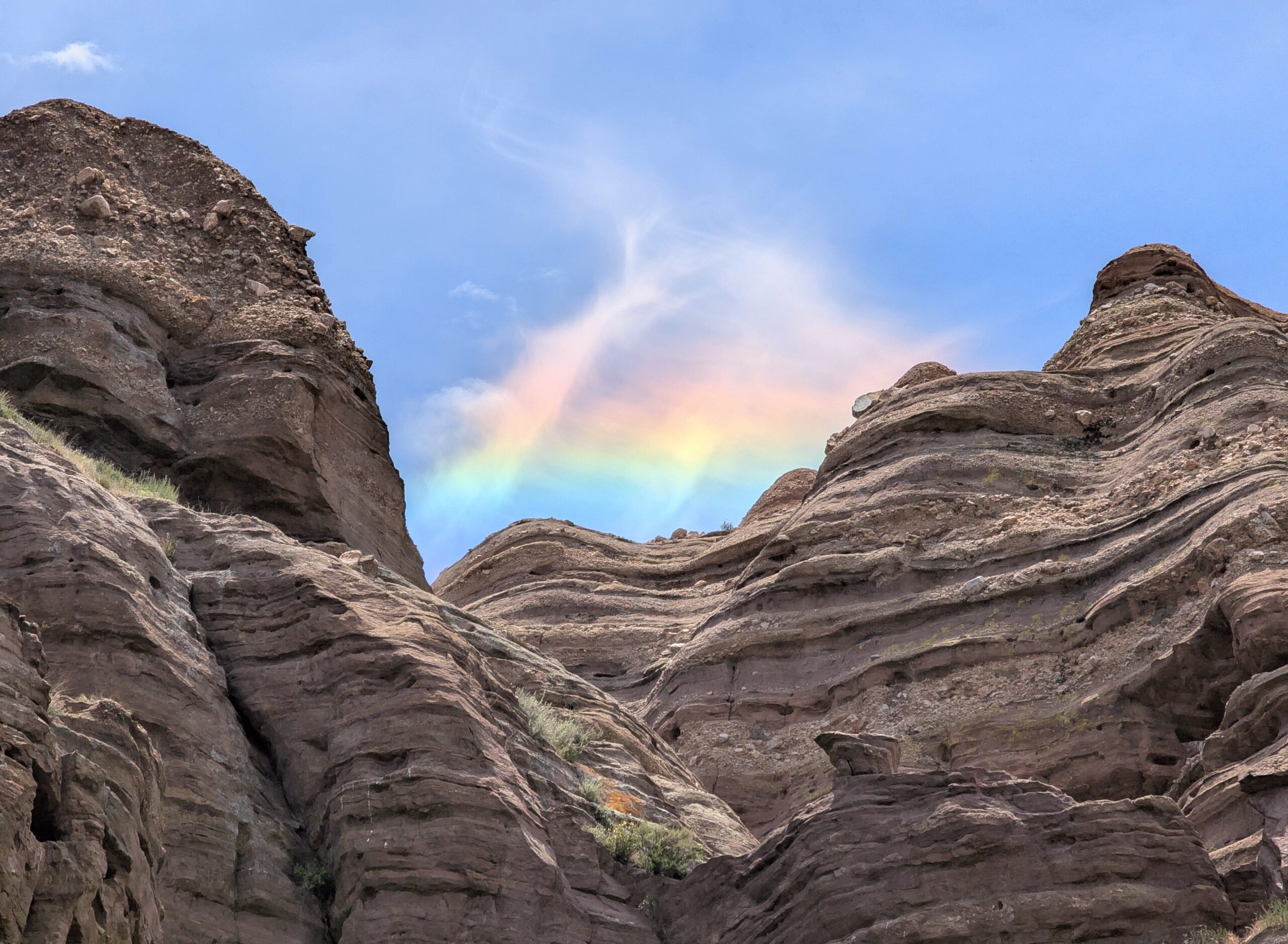
Famous as film location for countless Hollywood movies, the rocks really do look like an alien planet on Star Trek. We navigated corridors beneath smooth, red cliffs and climbed around rocks that looked like giant daggers protruding from the earth.

A lone cloud in the sky was reflecting the full spectrum of light above the rocks. The phenomenon is called cloud iridescence, and it was both fascinating and beautiful.

We made brief stop in the Vasquez Rocks Visitor Center to finally pick up our PCT hang tags. After that, we walked into the rural farm town of Agua Dulce. Spout demanded a gourmet coffee at the Mercantile before we took lunch at Maria Bonita. This was easily the best Mexican food I’ve had on trail and that’s not just the hiker hunger talking. This place had delicious food, big portions, nice presentation, and even gave us huge, 32oz cups of ice water.

We walked a bit further down the road to the Oasis camp, which seemed like a cool spot but was charging $60/night for us to pitch our tent in a yard. Instead, we hiked out during sunset to the middle of nowhere and made our own oasis. Though we were seeking some privacy, a pack of howling coyotes reminded us that squatter’s rights did not apply here.


5/17 – Day 28
19.6 miles from Dispersed Campsite to Green Valley Fire Station
Former PCT hikers love to brag about how they did not experience a single day of rain on the trail. Meanwhile, when we woke up today, it was raining. When we went to sleep, it was still raining. If it stopped at any point, I could not tell the difference. The entirety of Green Valley was engulfed in a dense, misty fog and there was nothing to see or do, except hike of course.

The trick here is disassociation. A major part of the mental game is learning how to detach your mind from the physical self. Allow the water to seep into every inch of fabric covering your body. Feel the chill of the wind deflecting off your skin. It is only uncomfortable if you let it be. Eventually, in a few hours, days, or weeks, you will be warm and dry again.

It seems everyone hikes faster in the rain. Spout and I completed over 14 miles by 1:00pm with just a single snack break. No reason to sit and get wet when you could walk and get wet instead. We eventually took a lunch break sheltered under a wide oak tree, hoping the canopy would keep us dry. However, every gust of wind loosed a barrage of water from the leaves and we still left damp and unhappy.

The last six miles were equally uneventful. As previously mentioned, we were lucky if we could see fifty feet beyond the fog, so the entire afternoon was mindless leg movement. We eventually made it to San Francisquito Rd, which was conveniently only a mile or two from the small village of Green Valley. We honestly had no intentions to bother hitching in to yet another trail town until, of course, we realized we could dry off in a BBQ smokehouse and wait out the rain.

The Green Valley Smokehouse was owned by a disc golf enthusiast named Dylan. He and his friends grilled some mean BBQ and were very accommodating to the hikers taking refuge inside. We ran into Alan again and also made introductions to a father and his little 11-year-old daughter, Gummy Bear, hiking the trail together. Dad goals.

When the misty rain returned to fog, Dylan offered us a ride back to the trail and we setup camp by the Green Valley Fire Station. All is well that ends in a (mostly) dry tent and warm sleeping bag.
5/18 – Day 29
24.8 miles from Green Valley Fire Station to Dispersed Campsite
Spout implemented a reward system for herself in the morning, earning a treat each time she put on a wet article of clothing. On went her soaked sun hoodie, down went an oreo. Damp shorts, oreo. Wet socks, another oreo. I thought it was stupid until I realized it was the fastest she’s ever gotten ready in the morning.


We have a bit of a toxic relationship with the PCT. After a day of some of the lousiest weather imaginable, we were so over it. Then, we get sucked right back in when the skies clear up and the high is in the 60°s. It was an absolute joy to hike the mile and a half uphill to Grass Mountain.

The terrain of pretty much the entire PCT thus far has been very forgiving. It is not “flat” per se, but the switchbacks are gradual and the overall elevation change is low compared to any other trail we have hiked before. We cruised through the morning mileage with ease, chatting with Alan about his career in software engineering. Spout has since dubbed him Spy, since he always seems to be doing that weird voice-to-text thing when he is on his phone.

We passed an old prospect mine that had a tight entry we had to crawl through, before opening up into a fairly deep passage. It was exactly how I setup my strip mines in Minecraft.

We continued hiking a while longer, stopping once to fill up water at spring, and settled on a lunch break in a clearing surrounded by poodle dog bush. Poodle dog bush is a toxic plant that causes a nasty, blistering rash on contact. We have been doing our best to avoid it, but might feel safer if we were wearing pants.

We traveled along a stretch of grass hillsides shaded by oak trees, almost in awe at how pleasant the trail was in the current weather. After several more miles, we came to what felt like the first milestone that warranted a good pat on the back: 500. Someone cue that song by The Proclaimers, time to do it four more times.

We reached a cistern that collected rain water and dipped in our bottles. After filling, we hiked down to a quiet campsite shared with Spy. Our evening routine is pretty simple: pitch tent, inflate sleeping pad and pillows, lay out quilt, light up the stove, boil water, cook beans, eat beans, fight over who gets the last bite, rinse out pot, eat snacks, brush teeth, lay down in tent, look at the map for tomorrow, journal, go to bed.


5/19 – Day 30
31.9 miles from Dispersed Campsite to Cottonwood Creek
We planned to wake up early, but smashed snooze a couple times and were not awake until 6:00am. We debated several options for our strategy today, which was more convoluted than usual due to the upcoming section across the LA aqueduct.

In any case, we first needed to reach Hikertown. The hike began as a surprisingly pleasant walk through more greenery, with lush grass fields contrasting the barren plains of the Mojave desert visible to the north. Soon, we entered a more familiar scene of sandy hills and scrub brush. The weather played to our advantage and temperatures were kept at bay as we rolled into Hikertown around 1:00pm.

Hikertown is an unusual place, to say the least. It is basically just a plot of land with crude, wooden shacks painted to resemble an old western town. We picked up two resupply boxes at the “Sheriff’s Office”, and poked around at some of the cabins: “Saloon”, “Mining Supplier”, “Feed Store”. One of the owners, Martha, gave us popsicles and a lift to the Naneech Market. We enjoyed a burgers and burritos in the company of an entirely new bubble of hikers.

Back in town, Spout and I both attempted an afternoon siesta, but could not manage to tune out the screeching wind turbines. The upcoming section followed along the Los Angeles aqueduct and is one of the most infamous stretches of the PCT. Supposedly, the heat here can be rather extreme, so many hikers choose to hike it at night. Since we seemed to be lucky with the weather, we shrugged it off and hiked out at 4:30pm. Our goal was to hike as late into the night as we could.

The aqueduct section began as a dirt road heading north from Hikertown. In a few miles, we reached the aqueduct, flowing swiftly through a wide, concrete canal. It looked completely out of place in the desert, but this is how I always pictured it in my head. After a short stretch along the water, however, the “real” aqueduct portion began.

The trail followed a dirt road next to a large metal pipe for a few more miles. To our right was nothing more than a desert wasteland, until we passed some invisible barrier and a forest of Joshua trees exploded in population. The dirt road turned to run alongside the aqueduct, which, from this point on, was hidden underneath a concrete platform roughly the same width as the road. For the next twenty miles or so, we had the choice of walking on the dirt or on top of the concrete aqueduct itself. The best part was that this entire stretch was table-top flat.

We took a break and sat on a structure to watch the sun dip beneath the mountains. Since leaving Hikertown, we had not passed a soul and felt like we had the whole concrete pipe all to ourselves. A skittish black-tailed jackrabbit was our only visitor. As dusk turned to night, we kept walking. Moonrise was not until much later, so aside from a bit of light pollution from Lancaster, CA, the stars were clear and vibrant.

The aqueduct led us right into a wind farm, though the turbines were not visible except for synchronized red lights. To escape the wind, we continued hiking until we reached Cottonwood Creek and scrambled down to the creek bed to find a protected site. It was after 11:00pm and we had traveled over 30 miles. I think I was asleep before my head hit the pillow.

5/20 – Day 31
23.6 miles from Cottonwood Creek to Tehachapi, CA (SureStay Hotel)
We slept well and woke up to the mechanical swoosh swoosh of the overhead turbines. With the help of the eight heaviest rocks we could find, our tent handled the wind just fine. We tore it down and continued hiking the last leg of the southern aqueduct section, eager to complete this somewhat tedious stretch of trail. The challenge today was that we had to complete over 23 miles to reach town. A bad habit is hiking too fast to make it to the road and we knew we had to accept that it was going to be a full day of hiking in the sun until we could turn the A/C down to 60° in our hotel room.


The trail rose gradually towards the next series of humble mountains. Six miles up plus one down took us into the Tylerhorse Canyon with cold stream water to fill up. At water sources, we make sure to “camel up”, meaning to drink as much as possible so that we do not need to carry as much with us afterwards. A liter of water weighs over 2lbs, so this can be pretty significant.

We completed the remainder of the climb with the help of headphones. Now, we just needed to make the long journey back down. The views to the north and the south were wind farms so unbelievably vast they almost seemed dystopian. The gentleman who gave us a ride later explained that this was one of the largest renewable energy farms in the world, producing so much solar and wind that California is a net positive exporter to the grid.

We unwound the switchbacks to reach Tehachapi Willow Springs Rd and scored another hitch. Checking into the SureStay, we took our first proper shower in a full week, and absolutely deleted some bulgolgi bowls from Four Seasons Cafe. Tehachapi is a bit larger and more sprawling than the other trail towns so far and seems obsessed with the fact that it is one of the few places in southern California that experiences all four seasons.

We spent the majority of the evening laying in bed watching The Office, eating Domino’s pizza, and complaining to one another about how badly our bodies hurt. Taking some pride in how far we made it is how we keep up morale. “I earned this by hiking 80 miles in three days”, I say, picking up a second pint of ice cream. “We are zeroing tomorrow.”
5/21 – Day 32
0 miles in Tehachapi, CA
Our first zero day of the PCT was mostly relaxing. I achieved my goal of walking fewer than 10,000 steps, but cut it way too close. In the morning, Spout and I enjoyed some coffee from Mountain Coffee House. Afterwards, we hitched to Walmart to resupply for six days (our longest stretch yet).

I went to see the movie, “Sinners”, at the local theater. It was one of the better movies I’ve seen in a while and featured a little bit of everything, even sexy vampires. Movies are arguably the best zero day activity, because they involve sitting motionless for two and a half hours eating snacks.

After the movie, Spout and I ate dinner at Luna’s Mexican Grill. To cap off the evening, we soaked in the hotel hot tub with Pixie and Pilgrim, discussing our plans for the Sierras, which loomed ever closer ahead.
What’s Next?
There is one final stretch of trail through the Mojave Desert. In about a week, we should reach Kennedy Meadows South. At this point, we are closely monitoring the snow pack in the Sierra. The snow is currently slightly above average, which means there is no rush to reach the Sierra and we should really be slowing down. We are planning to take at least 4 days off once we reach KMS to fly back to Pittsburgh and visit family.
How’s It Going?
Around 400 miles in, Spout and I both agreed we developed our “hiker legs”. My loose definition for this is the point where we no longer feel much fatigue in our legs or feet. It is as if our bodies finally understand that they are going to be hiking 20 miles per day, every day for the foreseeable future, whether they like it or not. Our daily mileage limit is more likely dictated by mental exhaustion than physical.

Interestingly, we have also begun the hobble around the same time. Now, when standing up after a long break or getting out of bed in the morning, our first couple of steps are stiff and uncomfortable. My feet and ankles resist standing up. I move like my hips need replaced with metal implants. I know from previous experience that this will only worsen with time. The good news is that it disappears once we get moving again.

After a full month on trail, the newbie excitement has waned. There have been a couple of days in the desert, typically when the scenery was unimpressive, where hiking has felt a bit more like a chore than a fun activity. However, the ups and downs are part of the adventure. With the highlights of the PCT just ahead, many hikers are ready to finish the desert and move onto bigger and better things.
Food & Resupply
The best part about eating beans every night is that whenever we get sick of them, we can easily switch it up. The classic style is eating the beans from the pot with Fritos crumbled on top. Or we could make a bean dip and use Fritos Scoops. There’s also the backcountry burrito; just fill them into a flour tortilla and voila.

The sugar cravings have also begun. Against my best efforts, I still find myself eating candy and snacks after a meal on trail. The alternative is to not eat anything, because there is a hard limit on how many bland energy bars can be consumed in a sitting. Junk food can apparently be consumed endlessly. My appetite is ramping up and calories are essential.

The good news is that both Spout and I are also eating more healthy food. Planter’s sells rosemary and sea salt cashews that are absolutely fantastic. Spout has been making overnight oats with peanut butter and honey. I am a huge fan of Bobo’s oat bars as an on-the-go alternative.
Notes
- I am relying on Google lens for pretty much all plant and animal IDs. It seems accurate, but I could be wrong on some labels