
4/23 – Day 4
20.7 miles from Laguna Campground to Rodriguez Road
The trail leaving Laguna Campground was the most scenic stretch we’ve crossed yet. About two miles in, we took a half mile side trail up Garnet Peak for a fabulous 360° view of the mountainous desert.


The terrain thus far has been exceptionally easy. Other hikers have commented that Spout and I hike fast, but we move at a pace that feels natural for us. After Garnet Peak, we knocked out several miles towards Sunrise Highway. Epic red cliffs surrounded the trail, with blooming patches of California Lilac that smelled delightful. There were at least three memorials dedicated to previous PCT hikers that had passed away, along with some moving passages.

We hiked through the morning and afternoon without a decent break. As 1:00pm came and went, we told ourselves we would take lunch in the next shady spot. Except, there was not a lick of shade to be found on any of the mountains we traversed. It was not the heat we were hoping to escape (it was in the 70s with a strong breeze), it was the unrelenting, direct sunlight. We eventually gave up and scarfed down our lunch in the sun before continuing ahead.

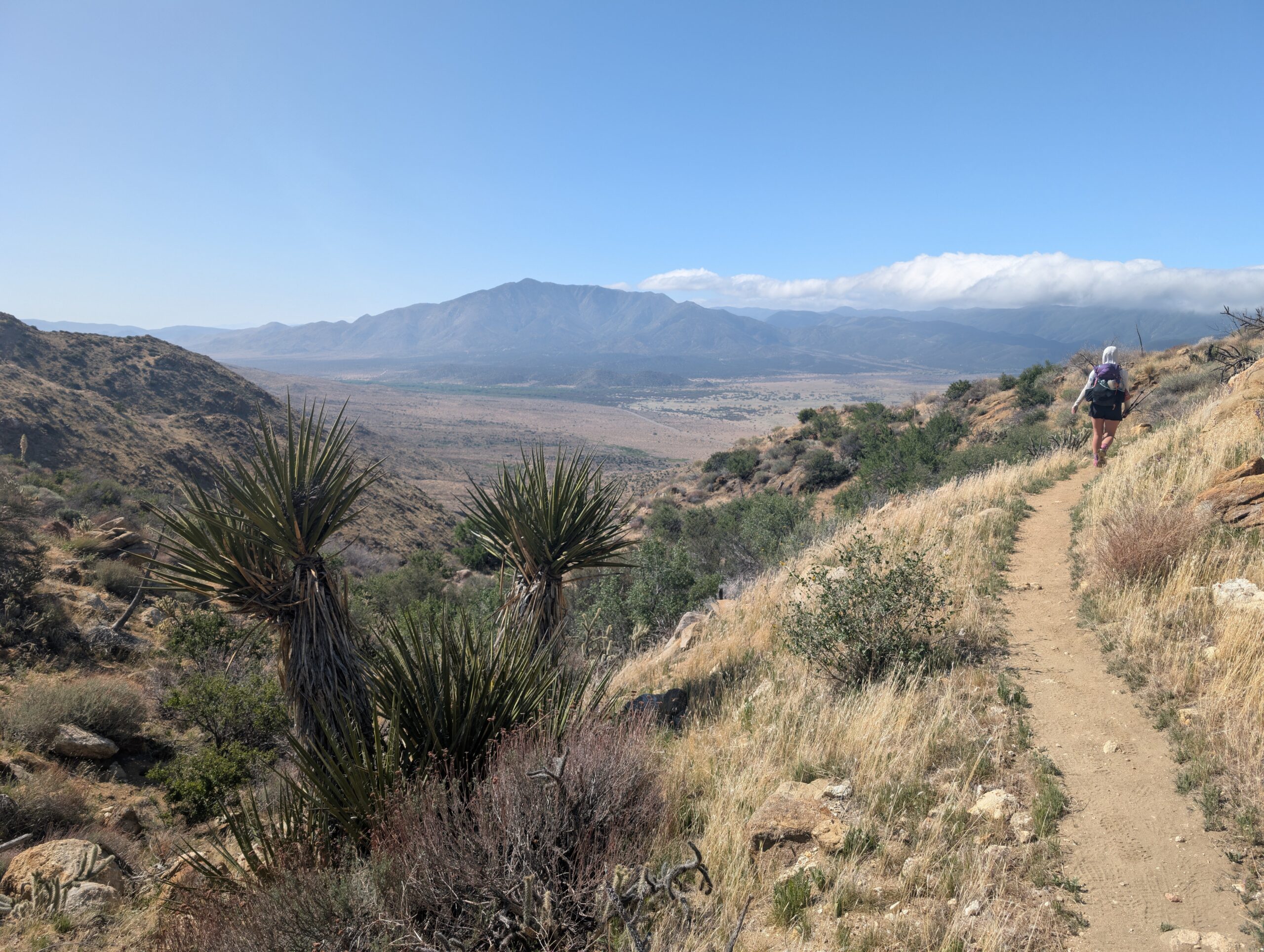
After a ten mile dry stretch, we reached a large, gushing pipe. As usual, mostly every hiker we had met was gathered at the watering hole. We took an hour and a half rest in the nearby shade, the made one final push for the day. The last six miles had tons of yucca and about three million lizards.

At length, we arrived at another water pipe with dozens of tents setup nearby. Water has been more plentiful than expected so far, but just uncommon enough to draw a crowd. After filling out bottles and eating dinner, we hiked backwards on trail to find a secluded campsite.


4/24 – Day 5
16.2 miles from Rodriguez Road to San Felipe Hills
I was awake early enough to watch the sunrise from our tent. Spirits were high and town was only 8 miles away. We navigated the desert hills easily enough. That is, until Spout let her guard down and smacked her hand into a silver cholla cactus, leaving a few barbed quills behind. To be clear, this was not during a round of Cactus Poke™. Spout was just doing some additional training.

The final few miles before we reached highway 78 had the most authentic, desert-like terrain yet. It was flat, sandy, and featured several species of cacti. We made it to Scissors Crossing around 10:00am, then Spout stuck her thumb out for a hitch. A sheriff drove past while we were waiting, but didn’t seem to care. Eventually, a nice gentleman in a pickup offered for us to hop in the back. Just like our first ever hitch on the AT, we found ourselves cruising into town in the bed of a truck.

The drive into Julian, CA took about twenty minutes. After being dropped off, we grabbed pancakes and a PCT power bowl at the Julian Cafe & Bakery. This was way too much food, considering we did not have anything remotely close to “hiker hunger” yet, but we managed to clean our plates regardless.

Next door was an incredible gear outfitter called 2 Foot Adventures with more ultralight, cottage brand gear than I have ever seen at a store. We resupplied, lounged around with some new friends, and grabbed a beer at Julian Beer Co. with Baby Yoda, Train Wreck, and Max. Finally, at 4:00pm, we got a return shuttle from the outfitter back to the trailhead.

Back at the trailhead, a budding entrepreneur was providing trail magic with his mobile bar, called the Pony Pub! Danny was a great dude and we found ourselves vortexed for another hour drinking summer saison. We eventually bid him farewell and started up the next mountain.

It is still unbelievable how different trails out west are, compared to out east. On the AT, we would have climbed directly up the mountain in the most punishing two miles you could fathom. Here, after a gentle, six mile stroll, we were still working our way up the hill. The sun was setting over the vast desert plains, but we wanted to keep moving and hiked through dusk with our headlamps out. At last, we found a nice clearing on the side of the mountain and settled down for the night.
4/25 – Day 6
16.7 miles from San Felipe Hills to Barrel Springs
Our tent was absolutely bullied by the wind all night long. Gusts of at least 30mph rattled the walls, knocking down the supports twice in the middle of the night. Fixing the structural integrity of your house at 3:00am is never fun.


We had a slow morning, trying to steal as much sleep as possible until 8:00am and then dragging our feet out of the sagging tent and into a frigid wind tunnel. Fortunately, things warmed up quickly and the continuing breeze made for a pleasant day of hiking. The trail continued its gradual ascent along the hillside for a few more miles.

Following a 15 mile dry stretch, we came to a massive water cache with hundreds of gallons of water hauled in by a trail angel on shipping pallets. We took a long break and even decided to fire up the stove for a lunch of refried beans and taco rice, since we had foolishly skipped dinner the night before.

The terrain was similar throughout the entire day, sticking faithfully to the side of mountain after mountain. One unique highlight was a random cave, just large enough for Spout and me to fit lying down side by side.

A few miles later, we caught up to a woman named Cheyenne. Our conversation was cut short when we crossed the 100 mile marker. More importantly, this meant we were 1/26.5 of the way done with the hike!

We descended even further and encountered an unexpected oasis leading to Barrel Springs. It was a green tunnel of oak trees with poison oak lining the sides of the trail, much unlike anything we’ve seen in the desert so far. Delicious spring water flowed from a pipe, and we decided to call the area home for the night.


4/26 – Day 7
11.4 miles from Barrel Springs to Agua Caliente Creek
We had our first overnight rain, which came as another middle-of-the-night surprise. Our clothes that were hanging outside to dry were nice and wet in the morning. Fortunately, we were close to Warner Springs, which offered an opportunity to shower and do laundry.
Before that, we had eight miles to hike through some diverse terrain. We left the springs and found ourselves in a sweeping meadow that we followed for several miles. The meadows left us exposed to the wicked wind, which made the temperature feel like it was in the 40s. At least the rain held off for the time being, despite the clouds looking like they were ready to pop.

We came upon Eagle Rock, which as the name would suggest, was a rock that looked like an eagle. It’s supposedly a sacred site for native American tribes that used to occupy the region.

By 10:00am, we had cruised into Warner Springs and went straight to the community center. There just so happened to be a “Trail Days” event going on. Plenty of hikers were gathered inside listening to a presentation on the PCT. The topics ranged from safety, to upcoming trail conditions, to wildlife, to inspiration, to tips on documenting the journey.

The man speaking looked vaguely familiar to Spout and me. When he said his name was Legend, my jaw dropped. We had met Legend and his cousin, Aaron, 6 years ago on the Superior Hiking Trail in Minnesota! To this day, we still crack jokes about our interactions with them, recalling how they saved our asses (literally) by giving us toilet paper when we had run out. It sure is a small world.

Another volunteer gave us a ride to the post office, where we had a resupply package waiting for us. However, we bumped this one up the trail, because we didn’t need it since there was a decent resupply at the nearby gas station and community center. The gas station also sold locally made sausages that were delicious.

Afterwards, we went back to the community center to shower outside, do laundry in a bucket, charge devices, clean our pot, listen to the same presentation three times, meet some new hikers including three folks from Slovakia, and finally, enjoy a spaghetti dinner. All of this was totally free and donation funded. It was truly amazing to see how much love and support cycles through the community.

Rain had been falling on and off throughout the day, so it was even harder to step away. When we left Warner Springs, it was nearly 7:00pm. We hiked three chilly, misty miles through cow pastures to find a campsite along Agua Caliente Creek.

4/27 – Day 8
19 miles from Agua Caliente Creek to Dispersed Campsite
For the second night and day in a row, it rained. The morning was a bit uncomfortable, since the condensation had invaded our personal space. We packed up our damp gear and hiked for four miles along Agua Caliente creek through spitting rain. To quote a random hiker I overheard later that night: “Why the hell is it raining in the desert? Isn’t the whole point of a desert that it never rains?”


After filling our bottles from the creek, we began a drawn out climb that would continue for nearly the whole day. Fog obscured some of the more distant mountains, but we were still treated to some nice views. The weather, albeit cold, was much better for hiking than the baking sun. We completed 12 miles by 12:00pm, our first “12 by 12” of the hike.

We stopped to eat lunch and were joined by a charming Frenchman, who went by the trail name, F**k-it. He is a triple crowner, back on the PCT for a second time. Spout and I brewed a pot of hot coffee as the three of us discussed politics and solved the world’s problems while covered in dirt.

After lunch, we hiked another two miles before a turnoff to Mike’s place. A water tank here was our last chance for water for about 25 miles. Mike donated his lot to the PCT years ago, and the result is one of the weirdest places I’ve visited. There was trash and random antiques strewn about the yard, and a few dilapidated buildings. F**k-it and I found some PBRs in a cooler, then hit some golf balls off the mountain. Some guy who seemed to just be living there was grilling up pineapple pizza. Strange place.

We hiked five more miles, passing Combs Peak, before descending the hills along winding switchbacks. At 5:00pm, it was chilly and we felt he had hiked enough. We stopped at nice campsite near the bottom and were joined by three more tents by dark.

What’s Next?
We are approaching Mt. San Jacinto, the first major climb of the PCT. There might still be snow over 10,000′ in elevation, so this will be a good warmup for the Sierra.
How’s It Going?
Up to this point, we feel quite good and the only thing preventing us from hiking more daily mileage is not wanting to push ourselves too hard. Our bodies need time to adjust to the insane volume they are receiving. Towards the end of a long day, we might feel a bit of fatigue and soreness, but nothing has been sticking around.
Morale is very high for both of us. Maybe this is still the “honeymoon phase” of the thru-hike, but being back on trail feels amazing. I feel clear-headed, social, and extremely grateful to be out here. Spout is thriving, as well. She is like a totally different person compared to when I would interact with her after a long day of work. Hiking is the best form of medicine.
Food & Resupply
Dehydrated beans and rice is a slam dunk meal. It is healthy, includes all the macronutrients we need, and is delicious. The biggest issue has been the limited quantity that we can make in a single 750ml pot, which we then split between us. Later in the hike, I fear it won’t be nearly enough food.

We’ve come across two unusually thorough resupplies in Julian and Warner Springs. Dehydrated refried or black beans are usually impossible to find but we’ve found them in both towns. Additionally, we ordered eight 6oz packs of refried beans online to ship to Idyllwild, CA up the trail.
Otherwise, we’ve been mostly eating energy bars, crackers, cheese, meats, and some candy.
Gear Changes
- The zipper on my LiteAF broke, so I purchased a new one in Julian, CA. The new one is made of EcoPak instead of DCF
- I picked up a dirty pair of sun gloves from a hiker box, since my hands have been getting too much sun
- We went through a 3oz bottle of sunscreen in 6 days. We are carrying two bottles now
Notes
- The mileage shown on Strava each day might be different than the mileage I log in the header. The header is using FarOut “trail miles”, but I’m tracking all side trips on my watch
- My watch stopped the activity when I plugged it in to charge in Warner Springs on 4/26. The remaining 3 miles are recorded but I won’t bother uploading it here
- Part of the reason we camped just outside Warner Springs is that the PCT enters Cleveland National Forest again for 12 miles just ahead of where we stopped. After this last stretch, we will be out of CNF for good and don’t have to worry about camping restrictions
Following this wonderful adventure!! Love you!!