
Where: The Nakahechi Route of the Kumano Kodo, traversing the mountains of the Kii Peninsula of Japan
When: 10/5/25 – 10/8/25
Distance: 40 miles (68km)
Route: Caltopo (includes bus routes)
Pre-Trip Information
Overview
Kumano is a sacred region in Japan that has drawn people for over 1000 years via pilgrimage across the Kii Peninsula. The network of routes is now called the Kumano Kodo. Those making the pilgrimage undertook rigorous religious rites of worship and purification along the way. The Kumano Kodo pilgrimage routes have since been registered as UNESCO World Heritage sites.

There are several routes across the mountains. The most popular is known as the Nakahechi Route, which begins on the east coast of the Kii Peninsula at the city of Kii-Tanabe and traverses the mountainous region in between to reach three grand shrines. Nowadays, the route can be explored using a mixture of transportation modes. In terms of a straightforward, multi-day hike, one of the best options is a walk from Takijiri-oji, to the grand shrine of Hongu Taisha. Then, the rugged trail continues southeast to the grand shrine of Nachi Taisha.

The Nakahechi Route of the Kumano Kodo is an excellent way to experience Japan’s serene nature, rural countryside, and even coastal towns. The villages along the route have preserved traditional Japanese culture. The route is far more than a typical walk in the woods.

The Tanabe City Kumano Tourism Bureau is an excellent resource to learn more about the Kumano Kodo.
Conditions
This trail is in the mountains and near the coast, so expect plenty of rain. It rained on and off for half of our hike. Otherwise, the weather we experienced was often overcast. Only one day was clear and sunny.

Japan is warm and humid for most of the year between April-October, which mostly aligns with the ideal hiking season. Temperatures were between the low 70Fs and 80Fs.
Gear
Since the Nakahechi Route does not require camping, there is not much gear that is absolutely necessary. Many travelers choose to leverage luggage forwarding services in Japan that will deliver their suitcases to their accommodation each night and just carry small day bags with them. This is a great, albeit pricey, option. Amy and I opted to store the bulk of our luggage at a storage facility in the Shin-Osaka train station, leaving just our traveling backpacks and select gear to carry on trail with us.

I created a simplified list of the gear I carried with me, not including food, clothes, and a few other unimportant things.
Important items to highlight:
- Boots/Trail Runners, the terrain is steep and requires shoes with solid tread
- Headlamp, emergency item in case you find yourself in the woods at night
- Portable Battery, to recharge electronics
- Wall Charger, to recharge electronics
- Poncho/Umbrella, rain is common and rain jackets are too clammy for the high humidity
- Pack Liner/Cover, rain is common and everything in your bag will get wet otherwise
- Cash, some of the businesses will not accept credit cards
Regarding clothes, laundry can be done at many of the guesthouses, so I recommend packing minimally (2-3 outfits) and washing as needed. Stick to quick-drying synthetic materials. It would be wise to carry a mid-layer, but it is likely not needed outside of winter.

If you plan to collect stamps along the way at each shrine (which you should!), it is worth bringing your own red ink pad. The existing ink pads are often dried out, resulting in very feint stamps.
Permits
No permits are needed to hike the Kumano Kodo.

Lodging
Though camping along the route is possible, I would strongly recommend for foreigners to book accommodations in towns along the way. Guesthouses are affordable, provide an authentic cultural experience including meals, and greatly simplify the required gear.

It is important to note that the towns along the route are small and have limited accommodations. I booked our stays 3 months in advance and the options were already dwindling. That being said, we noticed at least one random guesthouse advertising vacancies while hiking, so it might be possible to bank on cancellations and find last minute lodging. For simplicity, I recommend booking all stays 3-6 months in advance.

Koguchi is the only town between Hongu and Nachisan and it has very limited lodging. If you are planning to stay here, book as early as possible.
Food
It is only necessary to a carry about a half day’s worth of food on the trail. We carried one lunch per day and an assortment of snacks.
Every town we passed had either a grocery store or a small store ran by locals with a few snack options. Hongu has many restaurants, while a few others had one or two. Most businesses outside of the Hongu area open late (after 9:00am) and close early (before 6:00pm), which is important for meal planning purposes.

Guesthouses sometimes provide an optional dinner and breakfast, or a bento box to pack out for lunch. We only stayed at one guesthouse that provided food, but wished we could have had meals prepared for us every night. I recommend paying for as many meals as possible when booking ahead of time. It was a lot of extra effort to figure out where to eat on the fly, plan around the opening hours of stores, and then have to walk across town after a full day of hiking. Plus, it is hard to beat traditional home cooked Japanese food.

Water
We each only carried up to 1L of water at a time. However, I recommend bringing enough bottle capacity for 2L.
There are potable water faucets scattered along the route, as well as the occasional bathroom with a sink. Additionally, vending machines can be found near some of the road crossings; these are fine options for a cold drink. I recommend a tasty electrolyte water called Pocari Sweat.

We carried a water bag and filter, but it was not necessary.
Transportation
The Kumano Kodo and its associated towns have a robust transportation network. It is simple to access and navigate the route without a car.
The closest international airport to the Kumano Kodo is Kansai, south of Osaka. Flying into Tokyo is also a viable option, as Shinkensen service between the two cities is fast and very frequent.

Kii-Tanabe is a coastal town that is considered the gateway of the Kumano Kodo. We were able to walk up to the train station in Osaka and buy tickets for the Kuroshio line that follows the coast of the Kii peninsula for 2 hours before arriving in Tanabe. Tickets costed ¥5,800 (~$40) each.
From Kii-Tanabe Station, there is regular bus service to many of the points of interest along the Kumano Kodo. Those attempting the pilgrimage can ride 40 minutes to Takijiri-oji, where the route officially begins. Tickets costed ¥1,470 (~$10) each.

From Hongu, Nachisan, some of the towns in between, and even various points on the route, there is bus service. We leveraged a bus to save some time leaving Yunomine Onsen. Once finished with our hike, we rode 20 minutes from Nachisan to Kii-Katsuura. Tickets costed ¥630 (~$4) each.
The following day, we took the same Kuroshio line for 4 hours in the opposite direction back to Osaka. Tickets costed ¥7,460 (~$53) each.

Beyond being a lazy convenient way to travel the Kumano Kodo, busses provide bail out points if the hike proves too difficult and allow for more lodging with flexibility. That is, if all of the accommodations in a specific town are booked up, consider looking up a bus schedule and try to find a place in neighboring areas.

10/4 – Day 1
13.3 km from Takijiri to Chikatsuyu (Harumoni Guesthouse)
Elevation: +3,068′ -2,393′
Following a train ride all the way from Hiroshima and a connection in Osaka, we arrived in Kii-Tanabe around 5:00pm the previous day. This town is the ideal gateway to the Kumano region. The Tanabe Tourist Information Center is connected to the train station itself and is an essential resource before beginning the hike.


We left our guesthouse in the morning and walked back towards Tanabe Station. We passed D’oh! Bakery on the way and stopped to pick up some snacks for the hike. The 7-Eleven at the train station provided the rest of the food we needed for our first day.

Just outside the station was a bus stop with regular service to Takijiri, the starting point for the Nakahechi Route of the Kumano Kodo. A line formed for the 8:30am bus and it was stuffed full with as many people as possible. The tight quarters forced us into conversation with our neighbors. People from all over the world were on their way to a tiny rural Japanese town to experience this sacred pilgrimage.

The bus ride to Takijiri took 40 minutes. Our first stop was the Kumano Kodo Kan Visitor Center. There was plenty of information available, along with some souvenirs and the all-but-essential stamp book that is needed to collect the stamps at each shrine along the way. In addition, we were carrying the dual pilgrimage stamp book that we picked up at the Tanabe Visitor Center. This was for special certification to those who hike both the Kumano Kodo and Camino de Santiago, the only two pilgrimage routes recognized as World Heritage sites.

Takijiri Oji was the first of many shrines we would pass. Oji’s are subsidiary shrines that served as rest stops and places of worship for pilgrims traveling the route. Traditional means of paying respect involved:
1. Performing a purification ritual by washing hands and mouth in the temizuya
2. Approaching the shrine and make a monetary offering of at least ¥5
3. Ringing the bell
4. Bowing twice
5. Clapping twice
6. Praying silently
7. Bowing once

After leaving the shrine, we began the hike, which was straight uphill for the first few kilometers. Halfway up the hill, we passed a sign marked “Tainai Kuguri test of faith”. This short detour involved crawling through an extremely tight cave, literally described as “passing through the womb” into the mountains.

Just outside of the cave, we spied a small crab crawling around. Japanese freshwater crabs are indicative of a healthy ecosystem and clean water supply.

With muddy knees and elbows, we continued climbing the first hill. Another Oji or two guided us until we reached Takahara. The Takahara Shrine was my favorite of the day, painted a beautiful red and protected with a small fence.

Beyond the shrine in Takahara, there were a few guesthouses, a vending machine, a water fountain, a small shop, and a rather splendid view of the Japanese countryside. I bought a rice ball and lemon soda to enjoy for lunch.

The trail took us up a steep cobblestone path out of the town, where we returned to a forest of neatly organized pines. It started to sprinkle, then eventually accumulated to a proper shower. We were still carrying our umbrellas and they came in handy as a less-sweaty alternative to our rain jackets.

Every 500m, there was a concrete post counting upwards. We cruised past twenty-six of these and a handful of Oji’s on our way to Chikatsuyu.

This town was a bit larger with a grocery store and more than a few restaurants, though most closed by 3:00pm. We resupplied with another day of trail snacks then walked over to Harumoni Guest House.

This place was an absolute gem. The house, although basic, had everything we needed. Our sleeping arrangements were two ground futons in a small room with a low table. Our hostess, Hiroko, made us hojiri tea to sip as we dried off and listened to the pitter-patter of the rain. For dinner, Hiroko made a huge serving of traditional home cooked Japanese food. She explained that her neighbor shot a deer, “bang! bang!”, which accounted for the minced meat in the croquettes. I had no idea what I was eating for most bites, but it was unique and delicious.

After eating, Amy and I talked to Hiroko for nearly two hours. She was the sweetest woman and spoke English decently well. It is amazing the depths a conversation can reach in spite of a language barrier. We learned much about the Kii peninsula, various regions of Japan, cultural differences between our countries, and little things that made us feel like we were not so different after all.


10/5 – Day 2
22.2 km from Chikatsuyu to Hongu (Guesthouse Hatenashi)
Elevation: +4,034′ -4,714′
Hiroko prepared us breakfast at 6:30am, and we fueled up on eggs, meats, and fruits before beginning our hike out of Chikatsuyu. It was a beautiful, sunny day with just a few clouds in the sky. The Kumano Kodo followed roads for several kilometers. We fell into stride with a quartet from Vancouver and chatted with them about our experiences in Japan.

Just one week prior, a section of the route that had been destroyed by a 2011 typhoon finally reopened. We were now able to make a steep climb on the original route and were treated to a dramatic view of the mountains at the top of the pass.

We held over our hunger with a variety of snacks. I had a bag of milk and sugar donuts and some particularly dry energy bars called Calorie Mate. Despite the terrain being slightly more forgiving than the first day out of Takijiri, the climbs were still quite steep and we needed all the energy we could get.

The trail passed several more Oji’s, where we stopped to pay our respect. Of these, Hosshinmon-oji was the highlight.

The Kumano Kodo continued a gradual descent towards Hongu Taisha. At one point, we popped out of the woods and were delighted to find… vending machines! Not just any vending machines, either. One of them had a large selection of ice cream, the perfect treat on a hot day. Never change, Japan.

We reached Fushiogami-oji, which was also the site of a tea house and a spectacular view point of Oyunohara. We enjoyed some coffee before finishing the last few kilometers of trail.

At the Sangen-jaya Teahouse remains, we crossed a small bridge and turned off the Nakahechi route onto the Kohechi route for a short ways. We walked another two kilometers to the confluence of the Mitsokushi and Kumano Rivers, where our stay at Guest House Hatenashi was found.

The guest house let us check in early and we showered and did laundry before anyone else arrived. Conveniently located next door was a grocery store, where we stocked up with food and beer. Flying above the parking lot was a flock of Black Kites, a common bird of prey in Japan.

For dinner, we went on a journey down the backroads to ほん和か (Google translated to “really peaceful”). The whole place was run by a single woman who served delicious okonomiyaki and yakisoba for cheap.

It was dark when we walked back, but we were guided by the light of the harvest moon. The guest house was busier now and we hung out in the common area. I had some Kirin beer and Amy tried some Strong Zero, a delicious lemon drink at 9% abv that hit her like a freight train.

We made friends with a Taiwanese woman named Ashley. Amy has been eager to practice her Chinese, especially since there was an influx of Chinese/Taiwanese tourists in Japan due to a national holiday. The three of us bonded over drinks, language lessons, and the wonderful country of Japan.
10/6 – Day 3
5.2 km from Hongu to Yunomine Onsen (J-Hoppers)
Elevation: +1,660′ -1,499′
A week or so before our trip, I made the last minute decision to add an extra day into our itinerary. Though not necessary, I wanted to be able to fully enjoy the Hongu area, as well as the nearby Yunomine Onsen. We slept in, then began our hike around 8:00am. The weather was overcast and it sprinkled for maybe twenty minutes in the morning.


From the teahouse remains, we rejoined the Nakahechi route and trotted through the woods. A short detour brought us to an overlook of Oyunohara and the massive Tori gate at the base of distant mountains.

A short while later, the trail descended to Haraido-oji. We were stopped by a friendly local who was passionately documenting foreigners attempting the pilgrimage. He requested to film a short video of us to post on his Instagram.

Beyond this, we finally reached one of the three grand shrines on the Kumano Kodo: Kumano Hongu Taisha. This shinto shrine was truly magnificent.

The complex included multiple buildings of worship and plenty of other points of interest along cobblestone walkways.

The nearby area has shops, restaurants, the Kumano Hongu Heritage Center, and a lovely trail leading to the Hongu Taisha Otorii. This gate is absolutely massive and a real sight to behold. In fact, it is the largest torii gate in Japan. Entering underneath leads to the Oyunohara Sanctuary, a calm and sacred complex of small shrines near the river.

We still had not eaten much in terms of breakfast, so we stopped at Mitsuashi Noodle Shop for ramen and rice. As expected, the meal was tasty and satisfying.

The Nakahechi route continues east towards Koguchi, while the Dainichi-goe and Akagi-goe routes form a loop that connect back near the Fushiogami-oji teahouse. We were only interested in venturing as far Yunomine Onsen, which meant that all that was left was a measly two kilometers. To our surprise, the trail returned to the woods and rose up-and-over a formidable hill before arriving at the onsen town.

Yunomine Onsen is a historic hot spring town with a direct connection to the Kumano Kodo. Those making the pilgrimage would often stop to soak in the rejuvenating sulfur water, which supposedly had special healing properties.

Tsubo-yu is the oldest onsen in the world and a recognized World Heritage site. It is set directly along the river, now protected by a rustic shack. We bought tickets for ¥800 and had to wait an hour before it was our turn to enter.

This was such a memorable experience. It felt like we were dipping into a pool rich with history in a truly unique setting. The water was hot, almost uncomfortably so, but we could add cold water as needed.

After the soak, it was time to check into J-Hoppers. Our room was tatami again, and the stay included access to three private onsens. We used one of the indoor ones in the evening. It was a great stay for an affordable price.

The only dining establishment in the entire town was You-got-it Bar. They served us steamed bamboo bentos with a variety of vegetables and pork.


10/7 – Day 4
27.5 km from Ukegawa to Nachisan
Elevation: +6,470′ -5,533′
An ideal Kumano Kodo itinerary would include a night stay at the village of Koguchi, splitting the final 30km to Nachisan in half. Six months before our trip, everything was already booked up. Instead, we booked a stay near Nachisan. However, our stay was later cancelled by the host because they “did not advise us to travel so far in one day”. Despite my attempt to explain that we were more than capable of hiking that distance, we were barred from staying there and had to plan elsewhere. I instead booked a guesthouse in Kii-Katsuura, which meant we needed to reach Nachisan by 6:00pm to catch the final bus of the day. The irony was that the route was now even harder with the added time crunch!

To reduce our concerns about the timing, we decided to start the day with a bus ride from Yunomine Onsen to Ukegawa at 6:27am. This shaved off a few kilometers of road walking through Hongu. One of the best part about this trail is regular bus service to most of the villages, allowing for more flexibility in lodging and bailout points, if necessary.

From Ukegawa, we began a rather chill uphill hike through a fern covered forest. It was a cloudy morning, and the viewpoint at Hyakken-gura was unfortunately whited out.

The most horrific nuisance we encountered on our journey were Asian giant hornets. These hornets were bigger than my thumb and would sometimes follow us down the trail even as we desperately tried to flee. We spoke to a woman who was stung by one and claimed it was quite painful, as I would imagine.

Around 10:30am, we completed 13km to arrive in the tiny village of Koguchi. We were hungry, but found that there were no open restaurants and the one grocery store had an extremely limited supply. After eating ice cream and chips for lunch, we were not particularly motivated to hike the upcoming stretch and wanted to bail. However, the bus service out of Koguchi is virtually nonexistent and we had no other choice but to hike on.

Echizen-toge Pass is the highest point of the Nakahechi route. The 5km hike from the bottom of Koguchi is a truly grueling affair. “Even the famous poet Fujiwara Teika (1162-1241) was at a loss of words after walking this section, stating in his pilgrimage diary from 1201 that, ‘This route is very rough and difficult; it is impossible to describe preciously how tough it is’.”

It amazes me that thousands of years ago, monks were capable of making this climb without the assistance of trap music. Amy and I reached the top, sweating buckets, and continued traversing rolling hills towards the next great view. Funami-toge Pass offered a rest area and a lookout to the Pacific Ocean.

The route followed several kilometers downhill, into Nachi Kogen Park, and concluded with a long staircase to Nachisan.

At 3:00pm, we reached Kumano Nachi Taisha. This grand shrine marked the end of our route. We payed respect to the Shinto shrine, as well as the nearby Buddhist temple, Seiganto-ji.

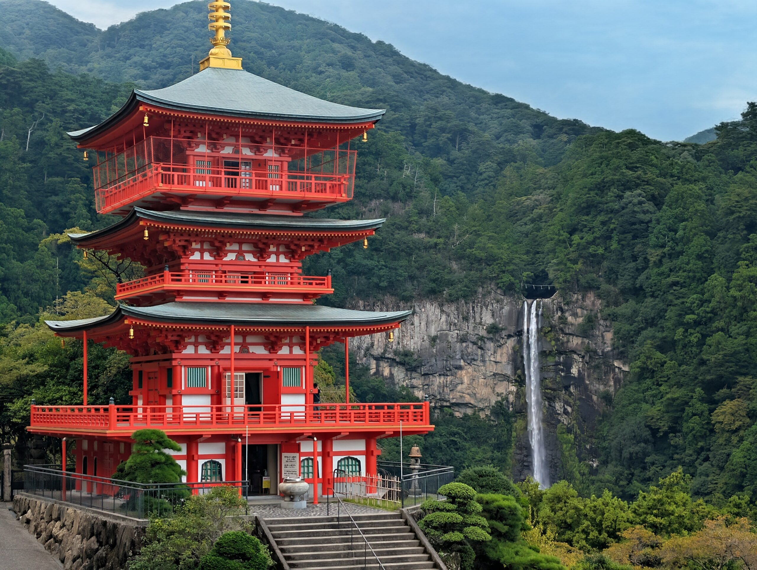
Just north of the Nachi Taisha was Sanjuno-to, a bright red, three-storied pagoda standing before Nachi Falls. This was the tallest waterfall in Japan and is believed to be a Shinto deity. The scene was absolutely remarkable, one of the most awe-inspiring sights of my entire life, and was a fitting end to this pilgrimage.

Exhausted from the long day, we did not explore too much longer before catching a bus to Kii-Katsuura. The ride was only twenty minutes into town. We checked into our guesthouse, Mune, then sought dinner.

Kii-Katsuura is a fishing town whose economic engine runs off tuna exports to larger cities, like Osaka. The locals, it would seem, eat very, very well, for cheap. Amy and I had bluefin tuna for the first time, served raw over rice at a small restaurant called Muromaru. It was fresh, tender, and unquestionably delicious.

To cap off the night, I went to grab a beer at a bar down the street called El Camino Del Poeta. It just so happened that two women who also just finished the Kumano Kodo were there for dinner, and we shared our experiences with one another.

We had a wonderful time on the Kumano Kodo. It was one of the highlights of our 3 week trip to Japan and a truly enriching experience that gave us a glimpse of a different side of Japan we would have never seen otherwise.
Feel free to leave a comment if you have any questions about the trail or just to say “hi”.
Stay dirty,
Alex + Amy